
Every time we drove or cycled out of town, passing Les Houches en route to Servoz or Passy, we would see this huge chunk of rock dominating the view off to our right. Turns out this is known as the Fiz massif. A little investigation also told us that there’s a decent little circuit going right around it known as the Tour des Fiz. If we had timed things better we could have registered for the trail race by the same name – on this occasion we just wanted to follow a trail at a much slower pace, preparation for our big hike in Corsica a month later.
The 2800 metres of elevation gain would be no match for the GR20 but would get our legs accustomed to ups and downs with a pack bigger than our current trail running vests. Distance wise there would also be no comparison; the Tour des Fiz being a measly 45 kilometres, broken up as 20kms on day one, then a further 26kms on day 2 – maybe there would be time to go bag Mt Buet as a side trip to make things a little more interesting! Either way the hike looks stunning and with the Covid-19 and weather forecasts looking to be perfect we were excited to be spending a couple of days away from home.
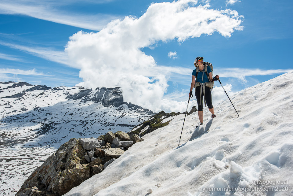
Mid June and still a whole lot of snow
Our departure point was Plaine Joux, a thirty minute drive from Chamonix, and the perfect location for accessing the endless trails above Passy and the Fiz range. This is also home to the areas best paragliding takeoff point – another of the activities high on our (my) bucket list!
We had never been up to Plaine Joux before so had no idea of the popularity of the place. Even early on a Saturday morning we were quite clearly late in terms of being out and about on the trails. Most people seemed to be here for day hiking and mountain biking – more commonly known in these parts as e-biking. What happened with cyclists actually using leg muscles instead of an electric motor?
We had no such plans for assisted forward motion and hit the trail, packs loaded, in the direction of Refuge Le Châtelet d’Ayères, the first of six possible accommodation spots on our typical route. With detours and alternate trails there are nine refuges within the Tour des Fiz area, potentially making this into more than a week long hike at an extremely relaxing pace.

At least the terrain was easy with all the snow

A nice little ridge walk
The goal for us was to make it to Refuge des Fonts, pretty much the halfway point, and looking to be before the beginning of a long drawn out climb (that could wait for the second day). We had no reservation but this being the year of the Covid there was no indication that things were going to be busy!
After having spent the past few months venturing out for the lockdown dictated hour maximum, the only weight being in our running vests, donning packs was a shock to the system. The first few steps out of Plaine Joux was an indication as to how things were going to be for the first couple of hours! However slow things were to begin it didn’t take long to get used to the pace and the gradual uphill motion – all that mattered was that we kept putting one foot in front of the other and didn’t think too much about how comparatively easy this will be compared to the GR20!
What began as wide trails in the lower resort area turned into a winding path below the impressive cliffs of Pointes d’Ayères. One day we’ll hike those same high trails at the top of Fiz! After a couple hours we’re climbing the final rocks that take us up to the days highpoint of 2257 metre Col d’Anterne – ahead we see snow, lots of snow. Not sure that tackling the upper reaches of Fiz is quite doable yet, something that we’ll remember for later in the season. The well trodden snow trail down towards Lac d’Anterne went on for 1.5 kilometres, descending 200 metres in the process. Luckily no need for microspikes! The glorious weather made lunch on the shores of the lake a no-brainer, so much of a no-brainer that we just continued right on by.
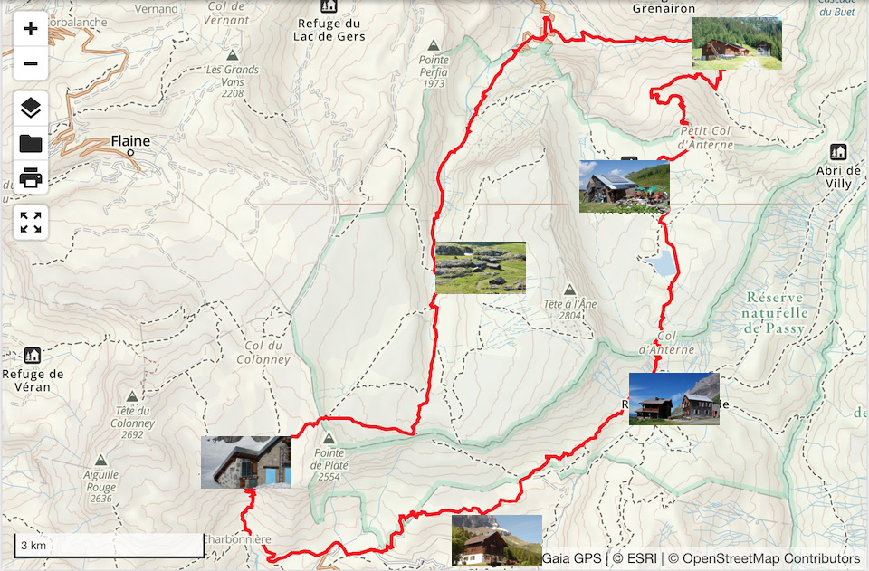
Route Map for the Tour des Fiz
With such a dominating rocky massif overlooking us it was almost surreal to be hiking through such green alpine pastures on our way to Refuge Alfred Wills. A little more than 2 kilometres further downhill this perfectly located refuge was another ideal eating stop – this time we obliged. Being a warm Saturday lunchtime there was also no reason not to wash things down with a cold, well deserved beer! From here the popular trail headed to the northwest, cutting out a chunk of the circuit as it passed by Cascades d’Anterne. Our route took us off to the east, following along a less well defined trail – a few trail runners were our only human companions as we first went up for a kilometre and a half, then down, down, down, all the way to our evening accommodation.
The 650 metre descent plonked us in the quaint commune of what I will call Chalets des Fonts; an amazing place that was most likely unreachable during the winter. The chalets must all be seasonal, including the refuge that had gladly allowed us to camp on their small piece of lush grass. What an adorable place to be able to vanish to for days at a time! It was now time for us to make use of everything we had been carrying for the past 5-6 hours – tent, sleeping bags, cookware, etc…
Probably due to Covid but we were the only guests on this beautiful Saturday night, quite surprising due to its location and warm hospitality. The family owners were totally okay with us camping for free, a gesture we thanked them for by polishing off a bottle of their wine and local cheese platter.

Refuge des Fonts; instead of a dorm we opted to camp
And just as they warned us… the cows complete with alpine bells came marching on right past our tent at sunrise, the young farmers leading them off to be milked. Not a bad way to be awakened we were thinking!
This second day pretty much consisted of a continuation of the prior days descent followed by fifteen kilometres of meandering uphill, with a final descent into Plaine Joux to end the tour. Everything about day 2 would be a little longer; the elevation gain and loss, the distance and the walking time. To begin we just had to follow the beat up access road heading out of the small commune. After moving back onto hiking trail for a bit we unfortunately entered civilisation at Le Lignon, its large trailhead parking lots busy with cars on this Sunday morning – we were about to get some trail company. This was apparently the main access road to the hiking trails on the north of Fiz, another area offering countless kilometres of new hiking trail.
It was time to begin the long days ascent. Within a couple of kilometres we reached the impressive Cascade de la Sauffaz, a great viewpoint of a side of Fiz we hadn’t yet seen and the tumbling waterfall. Continuing on following the Torrent de Sales, the impressive scenery always around us, we hauled our now not so heavy packs towards the Sales valley. This is definitely worthy of a night stop, the old wooden chalets looking very inviting, and the location providing access to the Fiz highpoint of 2804 metre La Tête à l’Âne, or The Donkeys Head in English.

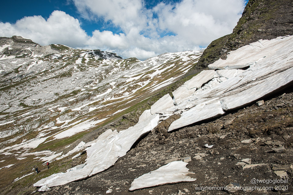
Slab of snow waiting to fall

Refuge de Platé
For some reason (probably the amount of snow) we decided to keep left at the next trail fork, missing out on the Désert de Platé, but still coming across route difficulties due to the snow cover and loss of footprints! We were still going uphill and could make out where we needed to head to, the sudden lack of people causing us to go off on our own trail – it was soon apparent that we were too high and precariously made our way back down to where our Gaia app had a trail.
Our goal was the 2354 metre Col de la Portette, also the days highpoint, before the final 8 kilometre stretch back to Plaine Joux. From a distance the steep and snow covered climb to the top looked intimidating, our concern soon diminishing once we were finally making our way to the top – what would the backside be like though? There was definitely the potential for one of the huge slabs of loose snowpack to come tumbling down, fortunately just not whilst we were below them! Once out of danger we soon found ourselves sitting outside the welcoming Refuge de Platé with beers in hand – another of the Fiz refuges we would like to spend a night at.
Almost finished, the final fun section a 300 metre/ 1000 ft descent over a very steep kilometre – it was hard to even pick out where a trail could possibly go on the rocky face. The well worn trail was most definitely there, and eventually mellowed out before joining the road leading back to Plaine Joux.
As well as this being a really cool weekend experience it left us with plenty of reasons to return; the many kilometres of trails and cool looking refuges, waterfalls and epic side trips to places like Mt Buet. Thanks Fiz, we’ll see you soon…
Day 1: Plaine Joux to Refuge des Fonts
Distance: 19.2km, Ascent: 1,230m, Moving Time: 4:57:27
Total Distance: 19.2km, Total Ascent: 1,230m

Day 1 elevation profile
Day 2: Refuge des Fonts to Plaine Joux
Distance: 26.5km, Ascent: 1,570m, Moving Time: 7:04:18
Total Distance: 45.7km, Total Ascent: 2,800m

Day 2 elevation profile
Hike Details
Start/ End: Passy Plaine Joux
Dates
June 13th – June 14th 2020
