
France had just removed its 100km travel limitation, Italy was about to open borders with its neighbors; still we were left with few options for a much needed vacation. We had been hiking like crazy in the Chamonix valley and needed something worthy of our fitness level. I had previously looked into Corsica due to its inclusion on the Century Club website, but off-season didn’t look so promising weather wise and the summers are usually hot and heaving with tourists. Fast forward to Covid-19 2020 – very few people willing or able to travel, still part of France so we weren’t leaving the country if suddenly the borders closed again, and a hiking hotspot. Even better, the small autonomous region had reputedly one of the toughest hikes in Europe; the Grande Randonnée 20, or GR20 for short. Time to book ferries, refuges and a couple of hotels…

Calenzana to Conca GR20 route
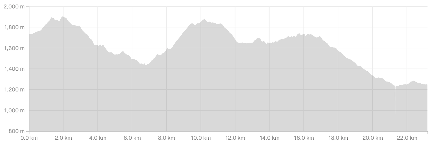
The 186km trail begins in Calenzana in the north of the island, ending in Conca in the south. Whilst not quite making it to the sea on either end it is in close proximity to the quaint towns of Calvi and Porto-Vecchio. Almost the entire hike is situated in the Parc Naturel Regional de la Corse, thus ensuring a pristine and protected landscape. Above Vizzavona, pretty much the northern half of the hike, is far more mountainous; the peaks considerably more jagged, exposed, and the terrain steep and almost entirely rocky – this is where 2,706m Monte Cinto is located, the highest point on the island of Corsica. The landscape below Vizzavona is far greener, less steep and rocky, but still providing plenty of ups and downs! We had read in numerous places beforehand that this is the toughest hike in Europe – would that hold up in our opinion?
The hike is typically broken up into 16 stages, each ending at one of the parks refuges. Due to the national park status it’s not possible to wilderness camp, the options being to stay in the numerous refuges, make use of the provided tents at the refuges or pay to camp at the refuges (bivouac) using personal gear. Typically this is the cheapest option at approximately €7 per person. There are also privately run sheepfolds, known locally as bergeries, pretty much setup just like park refuges, and also the occasional hotel and gite in the few areas accessible by vehicle. Incidentally we did see many individual campsites that people had built in various areas with a partial wind blocking wall around – this is probably okay as long as usage is from sunset to sunrise and ‘Leave No Trace’ is applied.

View from the Calvi citadelle

A short day 1 at only 6.5 hours

Calenzana and its mountainous backdrop
Sixteen days seemed a little too casual and with a limited schedule we initially cut that down to eleven, going a little more aggressively midway through the hike by reducing it to ten. Having to combine six of the days with others could end up being a big problem, especially in the north – one of the stages comes in at only 5km but has a timeframe of around five hours! It definitely appears that distances don’t give justice to the difficulty of this hike. It was decided that we would begin on a Friday morning, with Andrea only losing half day of work on that day, finishing before Monday at 2pm just over a week later – again, this would allow Andrea to work a full day on Monday. Our modified goal of ten days would mean we arrive at Conca on the Sunday.
Typical 16 day itinerary
- Stage 1: Calenzana to Refuge d’Ortu di u Piobbu (our day 1)
- Stage 2: Refuge d’Ortu di u Piobbu to Refuge de Carrozzu (our day 2)
- Stage 3: Refuge de Carrozzu to Refuge d’Ascu Stagnu (our day 2)
- Stage 4: Refuge d’Ascu Stagnu to Refuge de Tighjettu (our day 3)
- Stage 5: Refuge de Tighjettu to Refuge de Ciottulu di i Mori (our day 3)
- Stage 6: Refuge de Ciottulu di i Mori to Refuge de Manganu (our day 4 ending at Bergerie de Vaccaghja)
- Stage 7: Refuge de Manganu to Refuge de Petra Piana (our day 5 beginning at Bergerie de Vaccaghja)
- Stage 8: Refuge de Petra Piana to Refuge de l’Onda (our day 5)
- Stage 9: Refuge de l’Onda to Vizzavona (our day 6)
- Stage 10: Vizzavona to Refuge de Capanelle / Gite U Fugone (our day 7)
- Stage 11: Refuge de Capanelle to Refuge de Prati (our day 7)
- Stage 12: Refuge de Prati to Refuge de d’Usciolu (our day 8)
- Stage 13: Refuge de d’Usciolu to Refuge de Matalza (our day 8 ending at Bergeries de Bassetta)
- Stage 14: Refuge de Matalza to Refuge d’Asinau (our day 9 beginning at Bergeries de Bassetta)
- Stage 15: Refuge d’Asinau to Refuge de d’l Paliri (our day 9)
- Stage 16 Refuge de d’l Paliri to Conca (our day 10):
This is where things get complicated when mixing business with pleasure! The hike finishes a long way south and we either needed to have our car at the end waiting for us, or return to the beginning to collect it – only 2 bus companies and limited train infrastructure operate a completely lacking schedule throughout the island. The poor schedule became slightly better in early July; not quite in time for our arrival unfortunately. So, this didn’t allow for us to get the car to the finish line and return to the beginning for a Friday July 3rd departure – option 2 would have to work. Now how would Andrea be able to access her laptop that we hoped to leave at the beginning when we arrive in Conca? Initially planning on a Monday finish this was impossible due to the buses, so guess what…. I said that I would carry it throughout the entire hike! This was obviously a stupid idea; having to avoid any falls, not get caught out in downpours (very probable in the high mountains), and then there was the extra kilo and a half of weight! Obviously in hindsight we should have said to screw the bus schedule and pay an exorbitant taxi fare to go retrieve the bags, including laptop, we would have left in Calenzana. And so it was, I carried a useless piece of equipment for 10 days of adventure on Europes toughest hike!
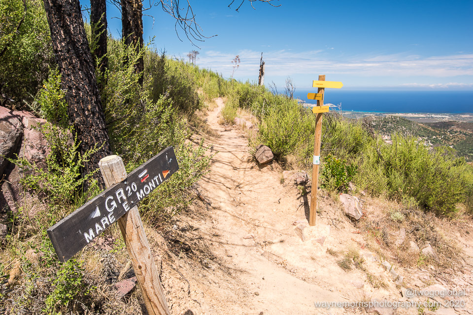
GR20 and the Mare e Monti trail

Happy for a lunch break on our first day
Whilst I had a plan in place so as Andrea wouldn’t lose time off from work I had also gone a little over the top on other planning – ensuring that we printed out the necessary Covid-19 forms for the refuges and bergeries (a complete waste of time as no one asked for them), made bivouac reservations for our first 3 and final 2 nights at the PNRC Refuge Booking Centre (turns out that we could have just strolled in to any of the refuges without a problem), and ignored the fact that there really were cooking facilities at every overnight stay. Quite possibly not having reservations would not have worked out any other year that a virus from hell wasn’t running rampant!
GR20 Day 1: Calenzana to Refuge d’Ortu di u Piobbu
Distance: 11.4km, Ascent: 1,447m, Moving Time: 4:58:41 Eventually departing at 11am, following the regularly painted white and red markings up through town before soon hitting trail proper. We weren’t slowly introduced to the incline or the temperature, instead both were thrust upon us from the very moment we started. Luckily the heat would subside unlike the hilly rocky terrain! Today we were doing a single official stage, partly due to the late start, mostly as this was our first day and we didn’t need to overdo things. Unfortunately this meant we would only cover a little over 11km, nowhere near enough for a 10 day finish. With the hot temperatures came a nice breeze, especially handy whilst out in the open en route to the days introduction to technical ascents – this would be the first of many times that carrying a laptop, a heavy DSLR camera, and few other unnecessary items would frustrate the crap out of me! Whilst my pack came in at 20kg plus camera Andrea had no lightweight load, tallying 16kg, mostly snacks, dinners and other food items. We had decided to be almost 100% self sufficient and were carrying all of our breakfasts, 8 days of dinners and 5 days worth of lunch food, then throw in some heavy granola bars (homemade by Andrea), and even fresh produce for the first day, and we were loaded. Great for saving money at the refuges but not good on the hips and shoulders! The highlight of the day were the two mountain passes, commonly known as cols, or in Corsica, boccas. The first, Bocca u Saltu, would take us up to 1250m before eventually topping us out at 1486m Bocca à u Bazzichellu. In stormy looking overcast skies we slowly rolled into a scenic campsite where many others had arrived from both directions before us. Still, we found a great spot, built camp, then headed off to find the showers and cooking area – a refresh and dinner were calling. It was now that we would discover that all the refuges, in fact all the refuges and all the sheepfolds/ bergeries, come with some level of hot or cold shower and provided stoves with gas and often pots and pans! We had read this beforehand but still thought it better to carry our own cooking equipment just in case – more unnecessary wasted weight, although we did have to use the cooking pot a couple of times. With some now appreciated evening sun it was time to look back on our first GR20 day over a cold beer. Funny that we had paid €11 for a single 50cl beer at the waterfront in Calvi the night before (bought in by vehicle on a modern road) and now up here where supplies are helicoptered in we are paying €6 for the exact same, perfectly cold, beverage. As expected the cool mountain weather kicked in nicely for bedtime. Tomorrow is going to be far bigger than the 1447m, 11.4km day we just completed and a good nights rest with an early start are in order…
Total Distance: 11.4km, Total Ascent: 1,447m


One of our better bivouac sites at Refuge d’Ortu di u Piobbu – nice and flat with great views

Probably not a smart move so early into the hike

Bocca u Saltu
GR20 Day 2: Refuge d’Ortu di u Piobbu to Refuge d’Ascu Stagnu
Distance: 12.3km, Ascent: 1,635m Moving Time: 9:30:52
Total Distance: 23.7km, Total Ascent: 3,082m

And all we had ahead of us was a comfortable 12 kilometres to cover in an entire day! This short distance was the total for official days two and three so we had no misconceptions as to how the trail might be, in fact le-gr20.fr, an extremely resourceful website gave the back to back stages more than 13 hours to complete. Thirteen hours for 12kms (approx 7.5 miles) we asked ourselves!
The terrain sucked from start to finish – always up, always down and always rocky and loose underfoot! We can bag similar altitude gains in Chamonix in 3 hours whereas this would turn into a 10 hour slog of a day. Fortunately it was mostly overcast and breezy, the kind of weather that these two hikers really appreciate when the going gets tough. The first significant climb turned out okay, the route allowing us a nice interim ascent and descent to warm us up before taking it on. A techy traverse followed, then one of those descents that’s tough on joints. This was taking far longer than expected, our midway arrival at Refuge de Carrozzu already into the afternoon – we were envying the lightly loaded trail runners with their five pound packs! We were both glad we were skipping a night at this refuge due to its shaded, almost view-less location in the trees. Still it was a welcoming place to stop for lunch and a water resupply before moving on towards the days second long and rocky climb.
Departing for Refuge d’Ascu Stagnu we were now covering the shortest distance day of the GR20 coming in at a whopping 5.5kms – five to six hours was the confirmed timeframe from a posse of fit looking hikers coming from the other direction. The weather made the gnarly ascent almost enjoyable, the clouds hiding what lay ahead, and Andrea’s steady plod of a pace eating away at the vertical metres. As is typical it didn’t seem like forever before we reached the first prong of this two-pronged ascent – we should never have asked a group of hikers how long to the afternoons highpoint of Bocca Di Stagnu! The descent to end our day was steep, very loose and never ending, our saviour being the old boy we got chatting with who was just returning from an epic run and who had completed the entire GR20 in 34 hours in his not-so-younger days. Badass!
For us, Refuge d’Ascu Stagnu wasn’t the best place due to its location being accessible by road – this did mean though that the infrastructure was slightly better, with a single hot shower, a well stocked indoor kitchen, fresh’ish loaves of bread and cheap beer. Also, due to our relatively late arrival we found the best positioned campsites already occupied.

The terrain we were about to endure…

Easy to follow trail with ample markers

Typical first half of the GR20

Plenty of times not to use trekking poles

Disappearing out of sight on the way to Bocca Stagnu
GR20 Day 3: Refuge d’Ascu Stagnu to Refuge de Ciottulu di i Mori
Distance: 16.5km, Ascent: 2,272m, Moving Time: 10:40:45
Total Distance: 40.2km, Total Ascent: 5,354m

The second of our big back to back combo days and another where we get to cover a silly distance. With stages 4 and 5 together we still only add 16kms to the tally – if we do the maths and assume that over 10 days we would have to move 18.6kms a day to achieve the overall distance we are so far behind. Instead of almost 56kms by the end of today we covered a paltry 40kms, and that included the couple of kilometre add on for tagging Monte Cinto!
This big day would take us to the 2,607m GR20 highpoint at Pointe des Éboulis, a little shy of the 2,706m top of Corsica at Monte Cinto. Somehow the opportunity to tag another highpoint would be too much to resist, even if the day was already set to be another long grind. Andrea would sit this summit out! The long steady 3.5 hour climb out of the refuge would be the biggest elevation gain of the GR20 and fortunately for us in the shade most of the way. One more hour following the difficult markings to tag the top of Corsica would see us almost dropping the same elevation as we had ascended that morning – funny how this big up down pattern was developing. Loose scree took us to Refuge Tighjettu which made the perfect stop for our homemade lunch and daily can of Orangina.
Continuing on to stage 5 this shortest walking day became somewhat easier, void of the really big elevation changes, and with an estimated 4 hour finish. We were hoping for a better camping site at Refuge de Ciottulu di i Mori which gave the incentive to push that little bit harder. Even with the significantly better terrain the GR20 still managed to throw us a 600m (2,000ft) climb to Bocca di Fuciale, the entire way with the afternoon sun beating down – it was from this vantage we could see where we were going but even the relatively short distance made us sigh!
Although this time the perfect campsite was snagged it was once again late in the day, the remainder of the suns warmth vanishing without time to take a quick cold shower or wash our sweaty and smelly clothes. The pasta with homemade dehydrated sauce and broccoli didn’t take long to hit the spot and make us forget about the big relentless day. Sleep came easily, especially with the thought of the following day covering barely a single stage!

Monte Cinto, the 2,706 metre summit of Corsica

Stunning rugged scenery of the northern GR20

Another really ‘enjoyable’ rocky descent

Moving from mountain scree to forest trails

Tomorrows route down valley
GR20 Day 4: Refuge de Ciottulu di i Mori to Bergerie de Vaccaghja
Distance: 22.3km, Ascent: 742m, Moving Time: 7:28:08
Total Distance: 62.5km, Total Ascent: 6,096m

At almost 23 kms this was initially to be the stage with the longest distance covered, eventually falling somewhat short due to an unplanned stop later in the hike! We were not quite covering official stage 6 as we had pre-made a reservation at Bergerie de Vaccaghja (privately owned accommodation also known as a sheepfold). The day would begin with a not-so-bad 2,000ft/ 600m descent into the Golu Valley and one of the few roads that we would encounter.
With a road came limited civilization, albeit enough infrastructure that included a hotel with a decent patio and proper coffee. Not sure why as where we had just reached had no significance, but still, we thought a little indulgence for reaching Castellu di Vergio was in order – a cheese baguette each and a couple of cappuccino’s. Unfortunately these mid-morning stops for supplemental food would not be the norm! We were almost at the days lowpoint, a fair way from where we needed to end up.
The meandering trail continued on down, taking us along an easy forest trail before the days ascent. We were in walking heaven after the gnarly terrain of the past three days – from all the research carried out beforehand we also knew that this wouldn’t last. The trail was not going to allow us an easy right of passage, at least not before reaching the 90km halfway point! The ascent went on for 4kms taking us back up from 1387m to Bocca a Reta at 1883m. We could now make the small descent to one of the highlights of the GR20; this was Lac de Nino, wild horses and pozzine countryside.
Pozzines are a landscape of vivid green lawns dotted with water holes, often called peat bogs as they’re made up of decaying plant matter saturated with water. This was magical, almost like an oasis sitting in the middle of the jagged mountains we had been through. The day was beautiful, the scenery was stunning, and the moment called for some lazy time at the lakes edge – full bellies ensured it was going to be difficult to get motivated and bag the remaining five kilometres.
The easy trail eventually brought us to our bergerie accommodation, and whilst still camping for this night we had the luxury of a meal. The area was stunning and unlike the late arrival at other locations we were early – early meant we had the pick of the crop to pitch our tent. The soft and flat grassy area for our site was going to feel so nice to sleep on! The shower was nice and hot, the beer was reasonably priced, and dinner was a meat feast – our only qualm being absolutely zero toilets; only natural peeing and pooping! Staying at the bergerie instead of Refuge Manganu, a mere forty minutes away, was the right choice as most people head straight on through, allowing us relaxation and a quiet nights sleep.
On another note we got to witness a potential record breaking GR20 attempt on this afternoon – French ultra trail runner Xavier Thevenard going for a sub 31:06 record blitzed through the sheepfold with his running entourage at 2.30pm. Unfortunately missing out by 86 minutes on the record.

Lac de Nino and the Pozzines

Obviously gets a bit breezy in these parts

Stopping to admire the endless views

Good reason for the name Bergerie (or sheepfold)

Looking out from Bergerie de Vaccaghja
GR20 Day 5: Bergerie de Vaccaghja to Refuge de l’Onda
Distance: 20.1km, Ascent: 1,421m, Moving Time: 9:27:35
Total Distance: 82.6km, Total Ascent: 7,517m

Today handed us another of those double stage days, the kind that amplify the already rocky terrain of the north. As usual we were up bright and early, making easy work of the short 40 minute hike to Refuge de Manganu. The initial “steep” 600 metres of up out of the refuge was a little easier than anticipated, with the upper section becoming quite a bit looser and rockier – we were used to this by now hence the reason it was easier than expected! Covering only 3 kilometres we had reached our days highpoint at Bocca alle Porte. That’s when the fun began.
We had read that whilst the lake views would be impressive the upcoming traverse was going to be a tough section; the writeup being pretty accurate! Over the course of about 4 kilometres we would drop and go back up a couple hundred metres, sometimes using our backsides, sometimes using chains and ladders, slowly making our way to Col de Rinoso and finally the beginning of the descent at Punta Muzella. The relatively high altitude lakes of Mélo and Capitello were both accessible using side trails, neither appealing to us enough to tackle the descents and then having to return to the trail!
The rocky trail continued from Punta Muzella down to the end of official stage 7 at Refuge de Petra Piana – this made a great place for lunch, especially with its significantly stocked store accepting credit cards. From here we had a decision; do we take the variant route that follows a supposedly technical crest without descending any lower, or the regular rolling valley path that involves a 400 metre ascent into Refuge de l’Onda.
I’m not sure we chose wisely! The descent to Refuge de Petra Piana wasn’t too bad, but then it just continued on down to under 1000 metres (the first time back at this altitude since day 1) – this was the usual GR20 style descent; long and rocky. In fact never ending rocks until almost the bottom. The saving grace being the meandering Manganello stream we were following – the day was sunny and the waters inviting. Thankfully we found the perfect oasis complete with private waterfall and deep cold plunge pool. Moving on from the water break, and just before starting the final climb of the day, we stumbled upon Bergerie Tallo – this would have made a perfect place to stay the night, tucked away in the trees with no other hikers in sight. Oh well, we had an agenda so a big loaf of bread and a cold beer would suffice!
Refuge de l’Onda was now a mere 400 metres of ascent, the progressively worsening Jeep track leading directly to an impressive, if not extremely busy, bivouac spot with restaurant and private accommodation. The location was perfect, the showers barely warm, and the grassy campsite welcoming – excellent place for night five.

The perfect place for our cold plunge whilst en route from Bergerie de Vaccaghja to Refuge de l’Onda

Return of the tough terrain – Bocca Muzzela

Refuge de l’Onda campsite
GR20 Day 6: Refuge de l’Onda to Bivouac Alzarella (Vizzavona)
Distance: 10.4km, Ascent: 753m, Moving Time: 5:48:29
Total Distance: 93km, Total Ascent: 8,270m

Although difficult underfoot and tiring at times the first 5 days had gone by without a hitch – the descent on day 6 temporarily threw a spanner in the works. This was a comment I noted down on the phone during the day… “absolutely destroyed and we’re only half way down this damn descent”. This day was all about the biggest descent of the GR20, taking us from just below the 2150 metre summit of Punta Muratello down to Vizzavona at 900 metres. To get to the beginning of that long rocky downhill first we had a climb, the final ascent of the northern GR20, and non too shabby at a 700 metre gain in 3 kilometres!
Departing Refuge de l’Onda with the sun still low in the sky was by far the best part of the day, things slowly deteriorating as we went. The trail leading up to Punta Muratello was a decent path, almost always in the sun and never too steep – then we had a decision to make; do we go bag another big Corsican peak, Monte d’Oro, adding another couple hours to the day, or de we continue on our merry way? It didn’t look much more gnarly than our current trail and as the islands highpoint was already knocked off there didn’t seem too much of a reason! So on we went, heading down.
There was nothing but a grueling, uneven rocky scree trail between us and the GR20 halfway point of Vizzavona, and with heavyish packs this sucked – we had been here many times already but this just continued on, and on, and on. I was becoming more frustrated and more beat up as we went, the thought of continuing on past Vizzavona to tag another double day far away in the back of my mind! Andrea seemed to be coping far better. Fortunately after the years of big mountains and long hiking days the knack to put one foot in front of another and suck things up was still strong – that didn’t stop the vocal cursing after every slip!
Eventually after 3 hours the terrain became a little less miserable and we came upon the English waterfalls, a welcome sight and a relaxing place to plunge a weary pair of legs into the cold water. The final hour into Vizzavona was along an easy jeep road – the question now became… should we have turned off towards the Col de Vizzavona to skip out on the small community complete with a railway station. We were back in the land of the tourists!
We made the right choice and even after gouging down on pizza and a cold beer the enthusiasm to continue hadn’t materialised. We were loosing out big time and this change of plan due to what felt like exhaustion was definitely going to set us back, dropping us around 16kms behind schedule! The official refuge, Bivouac Alzarella, was certainly not the most welcoming place we had stayed at so far but with its well stocked shop it was passable – being able to get hold of bananas, peaches and oranges was well worth it!
The rest of the afternoon was a blur, sleeping on and off to gain the energy for what would become our biggest day. I was really hoping that tomorrow the body will be back to normal.

Not sure we saw anything other than domesticated animals during the entire 10 days

It was nice to see green over just jagged mountains

Seemingly vacant bergeries were commonplace
GR20 Day 7: Bivouac Alzarella to Refuge de Prati
Distance: 31.8km, Ascent: 1,993m Moving Time: 10:56:14
Total Distance: 124.8km, Total Ascent: 10,263m

The prior days fatigue had faded away, probably just overshadowed by what lay ahead; 2000 metres of uphill and 32 kilometres in distance! I knew we should have sucked it up yesterday. Today, stages 10 and 11 were going to be combined, both significant in their own right – the first beginning in Vizzavona and ending at the Capannelle ski resort, the second closing the day out at Refuge de Prati.
Leaving Vizzavona we were now embarking on the GR20 south, the thought of more forgiving trails putting an early spring into our step. We had a nice gradual hill to begin, the kind that wakes the thighs up nice and gently, very much unlike the big crappy steep ones we’ve been accustomed to. This 7.5 kilometre climb would gradually take us up 700 metres to Bocca Palmente, and aside from some fluctuation this is the altitude where we would end the stage in Capanelle. Fortunately (almost) all we had to contend with were a couple of meandering semi-rocky descents along appealing looking streams. The only frustration being the final short descent into the intermediate stage refuge – just what we now expect from the GR20, a boulder ridden easy-to-twist-an-ankle path instead of the visible and easy road option!
Gite U Fugone was another rare stopover accessible by road – fur us seeing vehicles again meant people but also meant a better stocked restaurant and food store! After some refreshments we made a couple of decisions, the first being that we wouldn’t bother with the supposedly pleasant side trip to Monte Renoso, the other that we would continue on for the second even longer stage. This was mostly in forest until the final 5 kilometre/ 600 metre ascent. Gnarly, steep and as miserable as hell comes to mind, or at least that’s what it felt like after ten hours of hiking! There was a copout before making the climb – Relais San Petru di Verde (Col de Verde) was in the perfect location, looked very welcoming, had cabin accommodation and if it wasn’t for the fact that the following day would have begun with aforementioned gnarly steep climb, a great reason to call an end to the day. Instead, on we continued…
We could see people up ahead of us but didn’t seem to make up much ground – this climb really did suck, and it was hot, and we had already hiked for over 30 kilometres, and we were hungry, and on and on it went! Misery eventually turned into smiles as a sign indicating that we had made it up to Bocca d’Oru appeared on the crest. Attached to said sign was another for twenty more minutes to the refuge; WTF?
The location was a bit breezy but had an amazing setting, and to make things better we were able to buy baguettes from the friendly refuge caretaker. So we had made up the lost ground, Andrea’s brace fixed the intense sporadic pain coming from my right knee and calf, and we knew now that the terrain was finally on our side. The south is living up to its more forgiving reputation and the feeling was that we could now bag this thing in three more days.

Sunrise from Refuge de Prati

Almost the end of a very long day at Bocca D’ Oru

Refuge de Prati, our seventh night camping
GR20 Day 8: Refuge de Prati to Bergeries de Bassetta
Distance: 19.9km, Ascent: 1,166m, Moving Time: 7:55:27
Total Distance: 144.7km, Total Ascent: 11,429m
Prematurely we anticipated an easy day, and had it only been for the second of the days two stages this may well have been the case. Departing Prati, the sun beautifully illuminating the grass covered mountainsides we were itching to move another step towards the finish line – first we had to follow a ridgeline, a significant workout had we not been able to compare it to the northern stages!
And so off we went, the mountains beckoning once again; whilst still up there in elevation terms these weren’t the jagged grey peaks of the north but a little less dramatic, a mixture of greenery breaking up the monotony. After only a couple of kilometres we reached Punta Cappella, our highpoint of the day at 2041 metres, and from there it was pretty much a meandering descent along a scenic ridge for two hours. Passing back and forth along the ridge there were a few moments requiring the use of both hands and feet – the huge herd of goats we encountered made it look far easier! Moving on from Bocca Laparo we had plenty of prominent points to follow; Punta Bianca just a little lower than the days highpoint, Monte Formicula, and eventually a descent to the intermediary Refuge d’Usciolu.
Usciolu was the perfect distance from Prati, our arrival coinciding with lunch – fortunately this seemed to be the case on all of our double stage days. The rest of the day was set to be a stroll, made even more comfortable due to us already having a reservation at Bergeries de Bassetta, a few kilometres before the official stage refuge of Matalza. Leaving Refuge d’Usciolu an early batch of patchy annoying rocks greeted us once again, eventually leading into more comfortable terrain.
The day had gone well, the perfect weather from the beginning of the day staying with us throughout – very good reason to stop for a dip in an inviting watering hole to cool off. For once we had descended on dirt instead of rocks, the easy trail soon popping us out onto a narrow country road and our accommodation. We had chosen a privately run sheepfold instead of a park refuge so as we could try out the local cheeses and meet with the locals – we were the only ones with this idea, dinner and drinks being a private affair just for the two of us. Polishing off a bottle of wine and three courses of local produce was the perfect ending to the day. Tomorrow we would be back up above two thousand metres!

It didn’t matter how difficult or easy different sections were the scenery was always stunning

Early departure from Refuge de Prati

Far easier underfoot, even enjoyable

Window down to the valley far below

Heading up to stock Refuge de d’Usciolu
GR20 Day 9: Bergeries de Bassetta to Refuge de d’l Paliri
Distance: 23.8km, Ascent: 1,552m, Moving Time: 10:37:49
Total Distance: 168.5km, Total Ascent: 12,981m

Covering two and a bit stages day 9 ended up being our longest day by duration, our arrival at Refuge d’l Paliri taking almost 13 hours. The combo day would take us from Bergeries de Bessatta, past refuge de Matalaza, bergeries d’I Croci, an intermediate lunch stop at refuge d’Asinau and on to Paliri. We would be tackling three ascents with each becoming gradually easier – the first adding 700 metres to our departure altitude over 10 kilometres. Our reward for this climb… another steep and rocky descent! Honestly, the terrain was overall becoming noticeably better; more rolling grassy hillsides and less rock.
It wasn’t long before we reached refuge de Matalaza, probably looking the least welcoming of all the refuges so far. The trail was nice dirt road for the first couple of kilometres, soon taking a turn towards one of the most welcoming of the GR20 accommodation options, I Croci – this would have been the ideal location to have spent our previous night with its inviting menu and friendly staff. It actually seemed so nice that we stayed to devour the petit omelette. This could have easily fed two starving hikers! Maybe it was this mid morning meal that enabled us to reach Bocca di Chiralba and Bocca Stazzunara, both en route to the summit of 2134 metre Monte Incudine, so comfortably. Or maybe it was the daunting looking weather system hanging overhead that made us move more efficiently! We decided not to bother tagging Incudine as it looked nothing to shout home about and we had planned on taking a variant route later in the day which was not going to be easy!
Our second stage of the day would either take us through the picturesque Bavella Needles (Aiguilles de Bavella) or around them, the latter being longer and significantly easier. Ninety minutes after leaving Asinau it was time to make the decision; left or straight – I was up for the alpine variant whilst Andrea wanted the easy option. I won, let’s go! At the intersection the ascent up to Bocca di u Pargulu (providing access to needle number four; Punta di u Pargulu) began instantly, the steepness making up for the relatively pathetic 300 metres of altitude gain. This was nothing compared to the descent! Whilst the area could have been spectacular had we not already been hiking since dawn, for us it was all about reaching the road and bars at Col de Bavella – we were hot, thirsty and had no real desire for hanging around.
The descent began nice and easy before turning into a steep and technical scree hell – not sure Andrea ever smiled, especially when she took a good slide and kicked her heart rate up a hundred beats! At least we did end up cutting around 3 ½ kilometres off of the regular GR20 stage 15 distance of 15 kilometres. Not sure we wanted to believe it but the signage at Asinau had stated 7 hours to Col de Bavella – this surprised us at the time but ended up being a pretty accurate time!
Rolling into the busy Bavella village we found a place to sit, destroyed a cold beer, and pushed any thoughts of the remaining two hours far from our minds. Two more hours, how can that be! Yes indeed, there were still a couple more ups and downs to go to refuge de Paliri, a somewhat sprawling refuge setup. When we finally arrived, put up our tent and downed another cold beer, the day still seemed to drag – thinking about the looong walk to the drinking water spigot and really crappy cold shower! Finally rolling in to our sleeping bags at the end of our ninth and penultimate day did feel extra special.

Corsicas southern trails were far easier on the body than their northern counterparts

Highly recommended Bergerie d’I Croci

Horses of the pozzine

Bavella needles on the rugged alpine variant

Bocca Stazzunara below the summit of Incudine
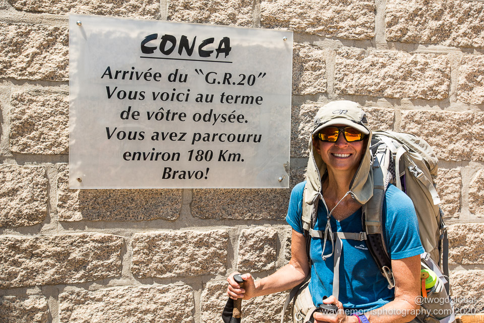
GR20 Day 10: Refuge de d’l Paliri to Conca
Distance: 13.6km, Ascent: 390m, Moving Time: 4:27:35
Total Distance: 182.1km, Total Ascent: 13,371m

Woohoo, the final day finally came, and whilst somewhat sad we were itching to get to Conca to grab a cold beer and chill out. It would have been even more exciting had we chosen the luxury of a hotel bed over another night camping!
Although this was to be our shortest hiking day there was still good reason the signage specified 5 hours! The trail was slightly better, and whilst primarily a relentless downhill the couple of short 100 metre ascents were steep and in the heat – we baked. This was the same brutally hot weather as ten days earlier when we departed Calenzana. We were certainly happy that it was a little less rocky than other days, the final kilometre or so into Conca even being on paved road. Plenty of hikers were heading towards us, this being their first stage – there was nothing to be envious about in this hot and humid weather.

That stunning bathing hole looked so inviting but the thought of the finish line just pipped it

Can we head north again?
Hell no, I’m glad that’s over with!
Final Thoughts
The south had many kilometres of rocky sections but nothing compared to north of Vizzavona. Overall there wasn’t too much terrain that wasn’t rocky; descents often loose slippery-as-ice scree, lots of big blocks to clamber over, some chains for assistance, a few alternate sections, and plenty of exposure.
Weather almost perfect, sometimes a bit too hot, sometimes breezy when we needed it, occasionally overcast, again when we needed it. Enough tree covered terrain for shade. First and final days by far the hottest, coinciding with lower altitudes and the time of day!
Would have been nice to switch refuges around a bit but our schedule wouldn’t allow it. Prati maybe preferred over Paliri, the sheepfolds of I Croci had better vibe than Bergeries de Bassetta (although we were the only guests!), and Col de Verde accommodation looked very inviting. Bivouac Alzarella in Vizzavona; whilst far from welcoming it did have a well stocked shop.
Almost every day arriving at camp we were physically beat up, significantly more so after the half dozen double stage days.
The GR20 is more than an adventure – worthy of its claim to being Europes toughest? Definitely a candidate!
Day 1: Calenzana to Refuge d’Ortu di u Piobbu
Expenditures
€7 bivouac x2, €6 beer, €5 Corsica biscuits ● (Refuge d’Ortu di u Piobbu)
Calories
Lunch: baguette, sausage, babybel cheese, tomato, sundried tomatoes
Dinner: mushroom & pea risotto with fresh parm cheese, Corsica biscuits & chocolate hazelnut spread
Snacks: homemade granola bars, tin sardines
Drinks: tea, coffee, beer
Day 2: Refuge d’Ortu di u Piobbu to Refuge d’Ascu Stagnu
Expenditures
€7 bivouac x2, €6 beer x2, €2 bread ● (Refuge d’Ascu Stagnu)
Calories
Breakfast: homemade oatmeal, dehydrated kiwi, banana, blueberries, powdered milk
Lunch: wrap, sausage, sundried tomatoes, babybel cheese, Corsica biscuits & chocolate hazelnut spread
Dinner: pasta with dehydrated sauce, broccoli
Snacks: homemade granola bars, tin sardines
Drinks: tea, coffee, beer
Day 3: Refuge d’Ascu Stagnu to Refuge de Ciottulu di i Mori
Expenditures
€7 bivouac x2, €4.50 dates, €6 oranginas x2, €7 beer, €2.50 crackers ● (Refuge de Ciottulu di i Mori)
Calories
Breakfast: homemade oatmeal, dehydrated kiwi, banana, blueberries, powdered milk
Lunch: wrap, sausage, sundried tomatoes, babybel cheese, tin sardines, biscuits and chocolate hazelnut spread
Dinner: powdered mashed potato, freeze dried beans, jackfruit
Snacks: homemade granola bars, crackers
Drinks: tea, coffee, beer, soda
Day 4: Refuge de Ciottulu di i Mori to Bergerie de Vaccaghja
Expenditures
€10 compeed, €2.15 coffee x2, €6 cheese baguettes x2 ● (Castel de Vergio)
€8 bivouac x2, €25 dinner x2, €7 beer x2 ● (Bergerie de Vaccaghja)
Calories
Breakfast: homemade oatmeal, dehydrated kiwi, banana, blueberries, powdered milk
Mid morning: cheese baguettes, coffee
Lunch: wrap, sausage, sundried tomatoes, babybel cheese, biscuits and chocolate hazelnut spread
Dinner: Stazzi di a Vaccaghja – meat!
Snacks: homemade granola bars
Drinks: tea, coffee, beer
Day 5: Bergerie de Vaccaghja to Refuge de l’Onda
Expenditures
€3.50 coke, €5 cheese, €3 sliced bread ● (Refuge Petra Piana)
€4 beer, €3 bread ● (Bergerie Tallo)
€8 bivouac x2, €7 beer ● (Refuge de l’Onda)
Calories
Breakfast: homemade oatmeal, dehydrated kiwi, banana, blueberries, powdered milk
Lunch: sliced bread, sausage, sundried tomatoes, cheese, biscuits and chocolate hazelnut spread
Dinner: tin sardines, fiesta corn – dehydrated rice, freeze dried corn, dehydrated zucchini, bread
Snacks: homemade granola bars
Drinks: tea, coffee, beer, soda
Day 6: Refuge de l’Onda to Bivouac Alzarella (Vizzavona)
Expenditures
€30 pizza, €2.30 crisps, €6 orangina & coke, €5 beer ● (Vizzavona)
€7.50 bivouac x2, €5 fresh fruit, €22 Baguette, cheese, 1/2 bottle wine, tin tuna, tin corn, fig bars ● (Refuge Alzarella)
Calories
Breakfast: homemade oatmeal, dehydrated kiwi, banana, blueberries, powdered milk
Lunch: pizza, crisps
Dinner: dehydrated lentils & rice with tin of corn
Snacks: homemade granola bars, crisps, fig bars, oranges, peaches, bananas
Drinks: tea, coffee, beer, soda, wine
Day 7: Bivouac Alzarella (Vizzavona) to Refuge de Prati
Expenditures
€2.50 oranginas x2, €2 crisps, €1.50 espresso, €1 twix ● (Gite U Fugone)
€2.50 orange juice x2 ● (Relais San Petru di Verde)
€8 bivouac x2, €2 baguettes x2, €1.50 snicker, €2.50 coke ● (Refuge de Prati)
Calories
Breakfast: homemade oatmeal, dehydrated kiwi, banana, blueberries, powdered milk
Lunch: baguette & cheese, crisps
Dinner: dehydrated sauce, pasta, tuna, baguette
Snacks: chocolate, crisps
Drinks: tea, coffee, soda, orange juice
Day 8: Refuge de Prati to Bergeries de Bassetta
Expenditures
€11.50 oranginas, chocolate, oranges, pate ● (Refuge Usciolu)
€9 bivouac x2, €2.50 orangina, €5 beers x2, €3.50 figs, €2 crisps, €20 bottle wine, €23.50 dinner x2, €13 cheese & €3 baguette ● (Bergeries de Bassetta)
Calories
Breakfast: homemade oatmeal, dehydrated kiwi, banana, blueberries, powdered milk
Lunch: baguette with cheese, pate & meat
Dinner: Corsican soup, veal stew and roast potatoes, baked apple
Snacks: chocolate, figs, crisps, oranges
Drinks: tea, coffee, beer, soda, wine
Day 9: Bergeries de Bassetta to Refuge de d’l Paliri
Expenditures
€8 cheese omelette ● (Bergerie I Croci)
€8 beer, €3.10 coke ● (Bavella)
€7 bivouac x2, €9 orangina, twix bars ● (Refuge de d’l Paliri)
Calories
Breakfast: homemade oatmeal, dehydrated kiwi, banana, blueberries, powdered milk
Mid morning: omelette & cheese
Lunch: baguette, cheese, meat
Dinner: dehydrated quinoa, freeze dried veggies, couscous, meat
Snacks: chocolate
Drinks: tea, coffee, beer, soda
Day 10: Refuge de d’l Paliri to Conca
Calories
Breakfast: homemade oatmeal, dehydrated kiwi, banana, blueberries, powdered milk
Transportation
Arrival: Livorno, Italy -> Bastia, Corsica, Carrier: Corsica Ferries, Cost: €91.58 inc car
Departure: Bastia, Corsica -> Savona, Italy, Carrier: Corsica Ferries, Cost: €64.89 inc car
Bus departure: Ste Lucie de Porto-Vecchio -> Casamozza, Carrier: Rapides Bleus, Cost: €18.00 pp
Bus departure: Casamozza -> Calvi, Carrier: Corsicar/ Les Beaux Voyages , Cost: €15.00 pp
Dates
July 3rd – July 12th 2020
IMAGES
I think that with trial and error both my photography and website design are getting progressively better so hopefully these newer, better quality images will inspire you to get out there and travel. Click HERE to see more and if you like the content then feel free to comment.
