
My choice was the Atlas Mountains of Morocco, Andrea’s some winter sun in the Canary Islands, the latter winning out. This was to be a Thanksgiving break for Andrea so how could I not be accommodating! The Canaries ended up as a win-win, and although my last visit was a drunken fortnight in my twenties on this occasion the Spanish island chain showed themselves in a totally different light. Our main reason for going was hiking and with a little delving into the opportunities we discovered La Gomera, the second from smallest of the islands and apparently a mecca for endless trails – GR132 is its long distance coastal route that covers 128km and over 25,000’ of altitude gain! We now had a plan and knew there was good reason for us having lugged a tent and cooking gear around Europe for the previous six weeks.
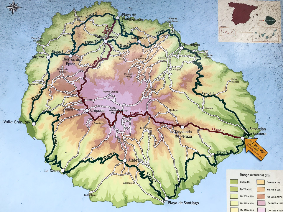
La Gomera’s 128km GR132 coastal route
Usually we pack ziploc bags of carefully selected food for our daily rations but on this occasion after reading a couple of blogs from previous hikers decided it would be easier to stock up with a couple days as we passed through villages. It was also entirely possible that we wouldn’t be able to get hold of a screw top propane cartridge for our miniature MSR stove, hence leaving us no way of even being able to boil water! Turns out that hardware stores, ferretería’s, and some gas stations stock them, larger than what we would normally take on a weeklong hike but we had no choice. Tenerife’s only Decathlon sports store apparently stocks them in various sizes and fittings. Other than the gas cartridge we found a perfect ham and cheese delicatessen in Los Cristianos and bought enough aged ham and manchego cheese to go with the sun-dried tomatoes and hot sauce into integral wraps – this was lunches taken care of.
Our biggest concern was definitely access to drinking water, also likely to be our biggest weight culprit! We had read that most of the fountains we were likely to come across would be dry and although we had a purifier with us finding clean enough standing water probably wouldn’t work. Reluctantly, bottled water it was.

Church of our Lady of the Assumption in San Sebastian

Christopher Columbus last port of call before heading off to discover the Americas

San Sebastian de la Gomera’s pretty harbour
The Fred Olson ferry whisked us over to San Sebastian de la Gomera from Los Cristianos in a quick fifty minutes, a little too fast to justify the total $155 return price tag! Still, the service was great with onboard WiFi for Andrea and cheap espresso coffees for me. We had one night accommodation either side of the hike, both nights spent in San Sebastian which was kilometer 1 and kilometer 128, dependent on whether we walked clockwise or counter-clockwise. Prior blog authors had decided to begin at stage 8 doing it in reverse, perfect reason for us to make that our choice too.
Due to us having to wait to be able to leave all unnecessary gear, clothing and electronics at our stylish accommodation we eventually departed a couple hours later than anticipated – with no distance plan all we knew was that we needed to be back 6 days later. The circular hike would take us through most, if not all of La Gomera’s larger towns, over mostly hilly volcanic terrain, past ruins, beaches and almost all on empty trails. From the signage at the beginning it was clearly going to be well marked (as are all of the long distance hikes we’ve done in Europe), separated into 8 stages with the last or first in our case, coming in at 20km.

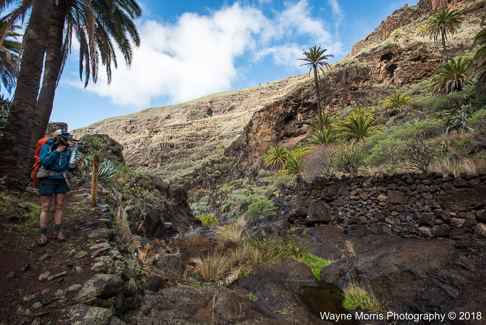
La Gomera terrain with well marked signage

All we had to do was follow these markers
GR132 Day 1: San Sebastian de La Gomera to Playa de Santiago
Leaving town, and as we were going to discover on a regular basis the trail followed a fairly steep incline, the main reason being the shape of the island – whilst it looked pretty circular the landscape had deep cuts that headed inland from the ocean. Known as barrancos, we were going to go up and down these whilst following their contour inland and then back to the water. What usually looked like a relatively short distance was always more substantial as we could never take the route that a crow flies!
At the top of our first climb at Barranco de la Guancha we were greeted by the rugged volcanic landscape that La Gomera is known for, complete with endless walled terraces that looked like they hadn’t been tended to in many years, cacti and tropical plants, with the occasional wild looking sheep. It was already easy to see how we were going to ascend well over 20,000′ in the coming days!
Pretty soon it was back to sea level as we headed down Barranco de Juan de Vera to the isolated resort of El Cabrito. Accessible only by sea this sustainable finca would be the perfect location for a couple of chilled and relaxing nights. Apparently there’s a water fountain attached to a bar but being fully H2O loaded we completely missed it.
Once again we moved on up towards our highpoint of the day at over 1,700′, passing by the ruins of Morales and Contreras. With wild camping being off limits in the Canary Islands both of these uninhabited farming neighborhoods would be perfect places to spend the night. We chose to stop only for our eagerly anticipated lunchtime wraps. Following our third barranco of the day, Contreras, the well marked trail once again made its way towards the ocean and the small tourist town of Playa de Santiago – by now it was 4pm and we had made it 12 miles, neither of us thinking of anything more appropriate than inhaling a cold beer or two! Less than 5 Euros later and we were on our way on the days final leg.
With sunset being a little after 6pm we were on a mission to find a suitable campsite, far enough away from civilization not to be discovered, and flat enough that we’d get some sort of a decent nights sleep. Seven hundred feet of switchbacks later we ditched our packs on a stony terrace overlooking town hoping that no one would stumble across our humble abode! We were soon to find out that with the sun setting so early and darkness falling not much later we were horizontal by 7.30pm – it didn’t get light until almost 7.30am meaning that we had far too many hours of downtime each night.
The day had gone pretty good, our legs given a good awakening to what lay ahead, a few rainy spells that would keep us guessing as to whether we should stop and add wet weather gear, and pretty spectacular scenery that would set the stage ahead.

Looking down towards Playa de Santiago from our first night campsite

The lush green oasis of Finca El Cabrito

Abandoned ruins of Contreras
GR132 Day 2: Playa de Santiago to Playa de Iguala
The chance that we might get discovered and the anticipation of devouring one of our regular healthy breakfasts before a long day were enough to get us up and about an hour before sunrise. We happily left an immaculate leave-no-trace campsite as we would go on to do every morning.
Today would continue as it had left off, initially following a steadily uphill and mundane trail before a series of long switchbacks to civilization and the days highest elevation at over 2,700′. Two short hours after breaking camp and we were chowing down on warm freshly baked bread and replenishing water at Alajeró’s fairly well stocked Spar grocery store – it didn’t matter that we had to detour to the opposite end of town for these luxuries! We had already passed by an open cafe bar so knew that my daily caffeine kick, another of life’s necessities, was not too far away. If each day went like this then life would be good.
Where there’s an up theres a down and although both of our least favorite directions we were left in awe at the beauty of more barranco’s. Hiking down and along Barranco de la Negra may have been our favorite section of the entire long distance trail; full of precariously cut terraces that looked unfarmable, palm trees along the valley floor, caves etched into the walls, and the mysterious screaming from goat herds. How and why farmers chose to keep animals and try to grow anything in such terrain was unfathomable. Looking both forward and back the narrow trail was indistinguishable at more than a hundred yards as it became lost in the vertical hillside.
GR132 continued lower and lower before it finally bottomed out at La Rajita, a small stony beach in Barranco de la Rajita. The final 800′ of steep descent was mirrored by a similar ascent of 800′ to the small town of La Dama, conveniently separated by a quick refreshing swim in the crystal clear waters of the Atlantic Ocean.
Although we couldn’t find a grocery store in town we did happen to walk right past a cafe bar that happily served up a couple of cold beers and topped up our water supply. They also stocked extremely limited food items.
Leaving banana growing La Dama behind the long switchbacks wound their way back down to the ocean at Playa de Iguala – we thought about spending our second night here but the obvious cave looked a little too lived in, and the derelict graffiti covered building unwelcoming! Once again we reluctantly took the steep trail uphill surprisingly popping out at a perfectly located site overlooking touristy Valle Gran Rey. Whilst the lights of town looked close it was a good six miles away; we were happy to be once again camping far away from civilization.

Sunset from campsite number two, the island of El Hierro to the far right
Deep inside Barranco de la Negra

Our first refreshing swimming hole at La Rajita
GR132 Day 3: Playa de Iguala to Arure
Day 3 and we were loving this hike; with its mixture of ups, downs, rain showers, plenty of sunshine, the occasional beer, cheap espressos, and amazing landscapes. We began today by seeing our first other hiker and a decent 2,000′ of elevation gain that took us away from the ocean and inland towards the small village of Gerian – with no grocery stores and no water fountains we plodded on through en route to La Gomera’s second most populous town, Valle Gran Rey. Even though we could clearly see the tourist town from our previous nights camp it took 4 hours of steady hiking to reach the outskirts and a further 2kms to find a decent place for brunch.
We were continuously left wondering who built these amazing trails and how much we’d like to thank them for making these hikes possible! Barrancos and terraces were once more the order of the day, then throw in cacti and a bunch of endemic plants, a cool little chapel that hosts a yearly festival, and a miserable downhill (for Andrea) into town, and that pretty much sums up through lunchtime.
Being in no rush and having access to grocery stores, cafes, and a perfect little swimming cove for some sweat removal got us geared up nicely for the big-ass climb back out of town. We eagerly took the opportunity to buy kiwi, persimmon fruit, and other fancy food items that we couldn’t get in the smaller Spar stores – next resupply point would be Alojera the following morning and being a Sunday we weren’t sure what would be open. Our biggest excitement was seeing the shower just waiting for us at the end of the small popular beach, unfortunately a shower that under closer examination had probably been disconnected for some time. Oh well, we’d just have to make do with another salt water wash. Definitely the worst thing about these refreshing swims was that so far they had been followed by a long sweaty mid afternoon hike!
The first couple of kilometres of our pm hike backtracked through town winding along narrow roads making its way to the marker indicating the end of stage 4. We had no plan for a possible place to camp, instead taking each kilometre at a time until we found something remotely suitable – this probably wouldn’t happen for the next 2,800′ of uphill. So much for the refreshing shower! The trail was no tougher than we had experienced on previous days other than the fact that we had maxed out on water supplies. My pack seemed to have weight similarities to the hefty loads carried on the JMT hike.
Taking a couple of hours to reach the days highpoint at La Mérica and with an hour or so left of daylight the hunt was on to find a sleeping place. Our vicinity to Valle Gran Rey meant we had seen too many foreign tourists out hiking and decided to skip past many perfect looking campsites on virtually flat terraces, instead continuing on along comfortable trails to the small town of Arure. We would definitely preferred to have stopped before this round of human inhabited dwellings and on this occasion found that trying to keep a low night time profile wasn’t so easy.
Not much more than a kilometre from town we stumbled across a perfectly carved cave right at the side of the trail, complete with a totally smooth floor and coming in at a little bigger than our tent footprint. We were pretty beat after our biggest climbing day and neither of us had any desire to continue! There was surely absolutely no reason why anyone would be walking this trail after dark so we were happy.

Reaching the top of cliff La Mérica at 2,100′ on a picture perfect afternoon

Touristy Valle Gran Rey seafront

First night we ever spent in a cave!
Not sure how well cave living could work for us as an hour after settling down for the night the centipedes that once seemed tightly fastened to the cave ceiling began dropping. Luckily for us the tent fitted perfectly without its flysheet and was promptly put up; still leaving a long night ahead but at least void from being ‘attacked’.
We left bright and early, the beginning of the day spent in low cloud, before dropping down far enough to enjoy the not-too-bad trail into Alojera. Stopping en route only to strip off our early morning clothing the surroundings took away from the fact that caffeine was still absent from the day – a small grocery store with attached cafe bar would soon see to that. The shelves had an ample supply of water, cheese and fresh bread, with the bar able to fulfil our coffee and tea needs. This was an amazing Sunday morning, our lives and views looking very good right now! The only dampener being a lonely old boy that complained to us that his friends had all died or moved away.
Leaving town was a mirror of the first hour and a half of the day, the ascent taking us back up to the same altitude we had camped. The steep cobbled path in warm early morning temps seemed to just go on and on, the only slight reprieve being a switchbacked road we had to keep crossing. At least with steep ascents altitude is gained pretty quickly and before long the sight of the only natural fountain so far came along – being on the tourist route and easily accessible by road we weren’t the only people enjoying the spring water of Chorros de Epina. This was the chance for Andrea to try and get the salt water from her hair and to top up water bottles again.
Close to the spring we also had a decision to make; do we take route 3 and descend down to the beach, Playa del Vallehermoso, or stay up in the mountains on the 6km shorter route 3.1. Both eventually merged at Las Rosas some 4-5 hours walk away. We decided to take the more mountainous option as it gave us the chance to head into the town of Vallehermoso for decent grocery dinner options. The trail downhill into town was the best descent so far, with sand underfoot and few rocks ensuring that whining from Andrea was kept at a minimum! Actually being able to enjoy the views of Mt Teide on neighboring Tenerife and Roque Cano overlooking town whilst putting one foot in front of the other was a new experience.
Neither of us having any desire for a hot or cold refreshment town was a brief visit, allowing just enough time for a quick grocery stop and snack, then immediately into the last section of the days ‘W’ descent, ascent, descent, ascent profile. The second 2,000′ climb always had us heading up towards the impressive looking Roque Cano, a huge rock that from a distance sat precariously above Vallehermoso – up close this behemoth lost its impressiveness and just became another huge rock face that we had to follow the trail around. We had hoped that once out of sight of town we’d have a fighting chance of finding a place to camp, this not being the case, and with the narrowness of the trail things didn’t look hopeful.
Finally we found ourselves heading down towards a small lake dammed at one end, the trail having become one of the rare sealed roads that we would walk on. Having returned to civilization there was little chance of finding a place to pitch a tent, the hope now being that as we headed back into trees and up a very narrow trail an opportunity would arise – as luck would have it and not long before the sun was about to set a few hidden and unused looking terraces appeared off the main trail. We were done and no longer cared if anyone came along now!

Roque Cano towering above Vallehermoso

For such a small island the road infrastructure was impressive

Morning mist shrouds the mountains above Arure

One of the best downhill trails we traveled

A discreet campsite nicely located on an old terrace
GR132 Day 5: Las Rosas to Enchereda
Having now passed the 90km mark we had two full days to make it back to San Sebastián, plenty reason enough to not depart camp until the ungodly hour of 8am! Today would end up being our longest walking day with only one long ascent. Immediately we headed down, and with another hikers blog stating that it was a slippery one we were mentally prepared for a long and slow descent – this didn’t end up being the case and we made a good pace all the way to Agulo. Surprisingly we had been walking for 2 1/2 hours and covered only 4 miles. So much so for our perceived good pace!
The sun was shining, the town looked really picturesque, and the first cafe bar we came across looked extremely welcoming… and so did whatever the couple at the adjoining table were eating. We didn’t hesitate to order a couple of the dense potato filled pancake looking things, along with coffee and tea. As usual this is exactly what these two smelly sweaty hikers needed! Another couple of kilometres downhill to Playa de Santa Catalina and we came across the first working shower of the hike (we had heard this was here and prayed that it was still connected). Not sure what the few other people milling around thought of us stripping naked to don beachwear for showering! Also we were happy that we couldn’t fully translate the sign attached to the shower post, probably stating that soap and nudity were strictly prohibited.
Feeling the most refreshed we had in 5 days it was time to start climbing again. In need of food for dinner and water a couple of kilometre detour into town was first necessary, me wrongly thinking that the onward trail was accessible by shortcut across a narrow ravine. Turns out that the route I had drawn with our trusty Gaia App was wrong for pretty much the entire day! Both back to feeling hot and sweaty we found the correct trail and plodded up a very steep 700′ zigzagging trail to the start of some of our most favorite scenery, Mt Teide showing off in its entirety.
The remainder of the day was spent following a little used dirt road that was probably just for access to the water pipeline that wouldn’t leave our side as it relentlessly followed us along the road. It was a great way for Andrea and I to communicate with when I got too far ahead; 1 bang to slow down, 2 for I’m in trouble, 3 for… On and on it went as we slowly made our way from 140′ above sea level to 2,420′ – the trail wasn’t so very steep but seemed to go on forever. Worse was that there was always a cliff on one side and a steep dropoff on the other, and no place to camp in between. Time was ticking by and with the next place name on our hike looking inhabited the latter few days of the hike, at least on our schedule, weren’t the most convenient for wild camping. Almost in the dark we rolled on past Encherada – if it wasn’t for dogs barking we would have thought it abandoned and may have camped close by. Instead we made our way off of the dirt road and back onto marked trail to what we eventually discovered would be our best campsite.
The worst part of our best campsite was the illuminated view of our endpoint, San Sebastián, looking far too close!

Our only freshwater wash, quickly followed by a sweaty uphill slog

One of the rare road sections

Our guiding pipeline went on for at least 10km
GR132 Day 6: Enchereda to San Sebastian de La Gomera
Waking on our final morning, wherever we’re hiking, is always somewhat disappointing. Why does this have to be the end we ask ourselves? Still, we managed to get ourselves motivated just as we had for the last four mornings, and again we had not been discovered. We had left absolutely nothing behind and felt like class A hikers!
Pretty much the order of the day was to get from 2,200′ down to sea level in 9 kms – day 6 couldn’t be any easier. The day was amazing with blue skies and whispy clouds, perfectly adding to the continuously spectacular terrain. We meandered up and down alongside herds of goats, caves, and fauna that we’d come so used to, before heading down getting ever closer and closer to unwanted civilization. Trail soon became sealed road and for the final few kilometres we were alongside cars, houses and barber shops! In a way we were kind of happy to be back at our official finish, the kilometer 1 and kilometer 128 GR132 signage.
At 10am we got to sit down in the towns square, newly displaying banners for the Talisker Whisky Atlantic rowing challenge, and drink an ice cold beer – this was far from the first over the past 6 days but was certainly the most deserving!
We’ll be back soon for La Palma’s GR130: Camino Real de la Costa

Fauna and the final trail back towards San Sebastian

Final nights campsite tucked away under the shrubs

Our welcome back to San Sebastian de La Gomera
Daily Hiking Stats
Day 1: San Sebastián de La Gomera to Playa de Santiago
Distance: 22.44 km, Ascent: 4,549 ft, Moving Time: 6 hrs 17 min
Total Distance: 22.44 km, Total Ascent: 4,549 ft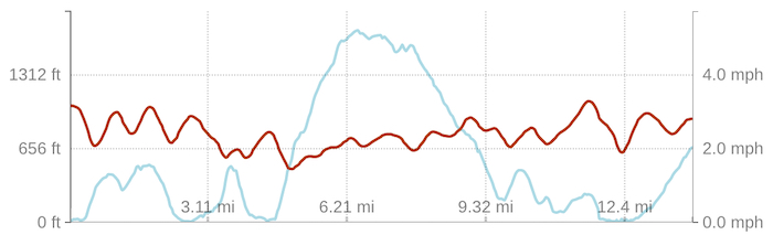
Day 2: Playa de Santiago to Playa de Iguala
Distance: 27.91 km, Ascent: 4,911 ft, Moving Time: 7 hrs 51 min
Total Distance: 50.35 km, Total Ascent: 9,460 ft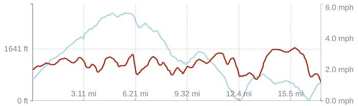
Day 3: Playa de Iguala to Arure
Distance: 22.65 km, Ascent: 5,844 ft, Moving Time: 6 hrs 54 min
Total Distance: 73 km, Total Ascent: 15,304 ft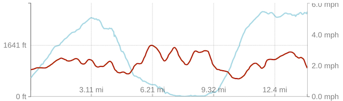
Day 4: Arure to Las Rosas
Distance: 21.37 km, Ascent: 5,108 ft, Moving Time: 6 hrs 48 min
Total Distance: 94.37 km, Total Ascent: 20,412 ft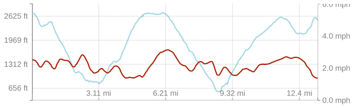
Day 5: Las Rosas to Enchereda
Distance: 28.85 km, Ascent: 4,743 ft, Moving Time: 7 hrs 54 min
Total Distance: 123.22 km, Total Ascent: 25,155 ft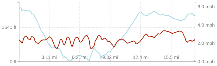
Day 6: Enchereda to San Sebastián de La Gomera
Distance: 8.87 km, Ascent: 542 ft, Moving Time: 2 hrs 17 min
Total Distance: 132.09 km, Total Ascent: 25,697 ft
Transportation
Arrival: Glasgow -> Tenerife South, Carrier: Ryanair, Cost: $80.20 pp
Departure: Tenerife South -> East Midlands, Carrier: Ryanair, Cost: $75.68 pp
Dates
November 22nd – November 27th 2018
IMAGES
I think that with trial and error both my photography and website design are getting progressively better so hopefully these newer, better quality images will inspire you to get out there and travel. Click HERE to see more and if you like the content then feel free to comment.
