I spent a week in Yellowstone for photography at the beginning of May so now it was time to return with Andrea. We reserved three nights at the Canyon campground located close to hikes, lodges, showers, and lots of wildlife. We added two additional nights after ensuring Andrea could get good Internet at Canyon lodge, unfortunately you have to pay for it. AT&T has service in Yellowstone, but it’s really spotty. Our phone shows 4G and 4 bars, but we’re unable to make calls one day and it’s excellent the next!
We’re both getting more comfortable hiking in the backcountry, but we always make sure we’re armed with our trusty bear spray and we try to be really observant because we don’t want to walk upon two cubs and their mother. We were hiking daily to prepare for our 100 mile hike in Europe later this year with our shortest hike at a mere four miles and longest clocking in at over seventeen miles. I really don’t think Yellowstone has the most beautiful scenery – it’s all about the wildlife! There are a couple of longer day hikes we definitely want to return for including a twenty miler to Mary Mountain that cannot be done as a multi-day hike due to substantial bear activity.
Yellowstone in May and early June is just about doable, with lots of other people, but not so overwhelming that it would make us want to turn around and get the hell out of there; however, a lot of the trails are still really muddy from high water levels and there is unpredictable weather. Bears are also coming out of hibernation and bear management is in full force closing a lot of the hiking areas until July. We would never want to visit in August – you could spend all day in traffic because someone spotted an elk for the first time.

Early morning mist over the Yellowstone River
Hikes
Black Canyon of the Yellowstone
Recommended as a three day hike by the Yellowstone Falcon guidebook, and after discussions with the backcountry office, we decided to at least give it a try in a single day. To make it a little tougher the hike was extended by four miles due to Hellroaring Creek being too high to ford – if we continued we would have to cover 17.5 miles and then hitch a ride back to the starting trail head. The hike went from the Hellroaring Creek trail head, followed the Yellowstone River, and finished at the Blacktail Creek trail head.
After arriving at Hellroaring Creek I assumed we would soon turn back since we had a limited water supply, no purifier, and a couple of sandwich bags filled with watermelon. This probably wouldn’t cut it for two people’s daily hydration needs! We trucked on and before long we were almost at the point of no return, with fewer miles ahead than behind us – now we would have to sally forth and hope we had enough liquids. This hike is the first time we have “encountered” a bear in the backcountry. We were sharing the trail with another couple and they were in front of us about 50 yards when we heard them turn-around and head back. They said there is a black bear ahead so we all armed ourselves with bear spray and proceeded in a pack of four. “Bears don’t attack groups of three or more”, at least thats what they say at the visitor center. It would have been more exciting if it were only Andrea and me. Luckily, when we rounded the corner, the bear was minding its own business, rubbing itself up a tree a few meters off the side of the trail. We had no other option but to walk past as a foursome as we talked nicely to the bear. It had no desire for confrontation and fortunately wandered off into the trees.
For the remainder of the hike we were alone, and with no more excitement we willed the miles to go by. This was hard work, especially since it was much farther than I had walked in a year, and carrying a fully loaded camera bag complete with tripod made it even tougher. Our arrival at the trail head was a joyous site, but now we had to hitch a ride back to car, something Andrea was dreading the whole day. Like magic, we put out our thumbs and the first car stopped. She was young and looked “normal”; we jumped in and couldn’t believe she was heading to the same trail head as us! What luck! We are always impressed with people’s generosity on our travels. Mission accomplished.
Cache Creek
With no real desire to walk too far, being the day after an extended hike, we meandered along an easy trail in the direction of Cache Creek in the Lamar Valley. We managed to cover a short four miles, and with no exciting photo opportunities we both decided to call it a day – our legs were paying the price from the previous day!

Lonesome proghorn unfazed by our presence

Cluster of Silky phacelia wildflowers
Mt Washburn
An incredibly popular hike, especially when started at the top of Dunraven Pass, the highest section of road in the park – we opted to take the alternate, far less populated route beginning at the Chittenden trail head, five miles along the Canyon to Tower road. As this trail was also open to bikes I had squeezed in a hilly ride around two thirds of the way to the summit the day before. Time restraints meant I couldn’t complete the entire ride, and thankfully not, as the remainder of the trail consisted of substantially steeper and very loose gravel.

The highpoint for the day, a mere 10,243 ft

The Mt Washburn fire lookout tower!
Andrea and I soon discovered that hiking nine miles late in the afternoon was fairly challenging, and at times had us thinking that we might be hiking back down in the dark without headlights. Fortunately this wasn’t to be, at least not for us – we did meet a woman, her young son, and the smallest pack, heading up as we were heading back down. Her car was gone the following day so we assumed she had returned safely.
Fairy Falls and the Imperial Geyser
This is definitely one of the more popular trails in Yellowstone beginning a few miles north of Old Faithful at the Fairy Falls trail head. We arrived late afternoon to a packed parking lot, something we like to avoid, even though most people were probably finishing their hikes. Our goal was to reach Imperial geyser, located thirty minutes beyond the waterfall – not sure why but neither of us get blown away by water cascading over a cliff anymore!

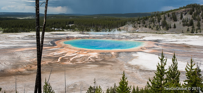
The all impressive Grand Prismatic spring
With the hike logging just under seven miles, and a sky that became progressively stormier, we barely made it back to the car without being struck by lightning. Early on in the hike we came across the unofficial viewing area for the impressive Grand Prismatic spring. Technically, the trails are off limits, but it doesn’t stop people, us included, from heading up to the various high points overlooking the spring. The trail beyond Fairy Falls leading up to the more remote geysers was the best part of this area since the trickling stream is highlighted with vivid blues, yellows, greens and oranges. It is amazing what colors all the thermal activity can add to this already beautiful forested wilderness.

Reaching out into the unknown

Imperial Geyser
The best way to explore Yellowstone during the busy summer period is definitely to head out away from the more popular trails, ideally the longer the better as most normal visitors do not venture far from the parks extensive road system. We came across very few hikers on our seventeen mile hike and found that when ‘waterfall’ is in the trail name it tends to draw loads of tourists. Next time we come in the winter for a totally different view of this amazing national park.
June 5th – June 10th 2015

