
Approaching Greenland ice shelf from the air was humbling, the size of the glaciers tumbling into the sea, the iceberg’s with their turquoise underwater colours, the sheer expanse… and we were barely north of Greenland’s narrowest point – there was a hell of a lot more land than what we could see! As we left the ice shelf the relentless white gave way to tundra, quite possibly our route for the beginning of the Arctic Circle Trail. Countless lakes, some with huge carving glaciers beckoned us as we approached Kangerlussuaq.
Kangerlussuaq sits at the head of the 190 km long Kangerlussuaq Fjord and 50kms inside the arctic circle. It’s home to Greenland’s primary international airport and is either the end or beginning of the ever more popular Arctic Circle Trail – hiking this was our primary reason for visiting the planets largest island.
Moving on, and after spending a night in Sisimiut it made sense to take the weekly ferry to one of the islands star attractions; Ilulissat and its monster icebergs. The tiny community of Oqaatsut and its population of 20 or so would be the next stopover for a couple of nights before hiking back to Sisimiut and a return flight to Copenhagen.
We needed just a bit of luck for this plan to be perfectly executed; the weather on this occasion being secondary. Our luggage not arriving in Kangerlussuaq was our biggest fear! The world seemed to be in a disaster with airport luggage, Copenhagen being no exception – at least we had driven to Denmark, ensuring that our backpacks would make it this far.

The ACT route from Kangerlussuaq to Sisimiut
I was fascinated about the ACT after coming across it a couple of years prior in an airline magazine, the seed well and truly set to make it out to Greenland. Finally after a couple of disastrous Covid years the gates to this island country opened up.
We were going to be spending 17 nights in Greenland, eight of which would be spent in the wilderness, far away from everything the modern world makes available to us. To fit in with flight and ferry schedules we were following the more popular direction, beginning in Kangerlussuaq and ending in Sisimiut on the coast of the Davis Strait 167kms later. The plan was to avoid all of the 9 huts on the route, not get caught in any bad weather, and be mosquito bite-free at the end!
To make things a little more interesting we were going to throw in a couple of variations to the 167km route and would instead be covering approximately 210kms over 8 days. They would include taking an excursion with Albatross Arctic Circle tours to Point 660 at the edge of the Greenland ice shelf – either we would camp there or walk 10kms back towards town and camp at Russell Glacier. Then due to a new ATV dirt road that had recently been created we had the possibility to take a lesser used southern route, detouring away from the main trail for a few days.

Russell Glacier, our night 1 campsite

Vast Russell Glacier coming off the ice-shelf

Albatross Arctic Circle

Greenland ice-shelf at Point 660

Ice-shelf moraine
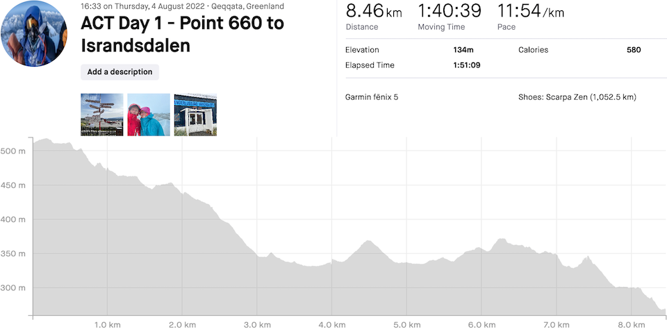
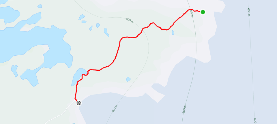
Arctic Circle Trail Day 1: Point 660 to Russell Glacier
Distance: 8.46km, Ascent: 134m, Moving Time: 1h40
With sunset at almost 11pm and sunrise at 4am it wasn’t difficult to be awake far too early! What was difficult was the sound of rain – hopefully the UK Met Office has it right and by the time we leave for Point 660 at lunchtime it should be nice, or even ‘okay’ out. One can hope!
After a final backpack check; camera lenses and everything, I was not excited about putting one foot in front of the other, preferring to look forward to the gradual reduction in the amount of food we were carrying. A quick bag weigh at the airport whilst waiting for Albatross bought mine in at 23kgs, inc heavy camera gear and Andrea’s at 19.5kgs inc a laptop and 2 bottles of beer. Sucks that this hike is point-to-point and we need to carry everything for the entire duration in Greenland!
The rain eventually subsided and we departed with another 70 or so tourists split between two big off-road trucks for the ice. The Greenland ice shelf is second only to Antarctica in size; we were barely going to see a pinprick section of it! The view from the dirt road was littered with lakes, glacial rivers, tundra, mountainous terrain, and even sandy desert… and for the final 12 kilometres, a lot of ice. Hopefully during the tour we’d spot a good place to spend the night camping.
After a couple of hours we made it to what is known as Point 660, a stunning location 38kms from Kangerlussuaq on the edge of the ice shelf, sitting at 660 metres above sea level (apparently more accurately at 585m). We toyed with taking our heavy packs and doing our own thing, but hey we paid €200 to learn something so decided to follow the group and take a walk out onto the ice. It was amazing, ice as far, and much further, than the eyes could see – we were mostly on the bit that looked dirty with moraine but it didn’t take much to look beyond!
Eventually we departed, set the Garmin running, and walked back along where we had earlier driven. We had plenty of daylight, the weather was probably pretty good by Arctic standards, and we had an idea of where we wanted to get to – maybe around 6-7kms. It wasn’t long before we had the fortune of an arctic hare eating just off the trail, then almost straight away a group of reindeer took off running on a nearby hillside. Just musk ox and Arctic foxes to see now; avoiding at all costs the very rarely seen polar bears!
Our planned campsite was as expected, stunning and void of anyone else. It was going to be a remote and lonely night. The view was second to none, the huge, sadly receding, Russell Glacier waiting to carve off its next chunk of ice into the glacial river below. It’s times such as this that make carrying 3.5kgs of camera gear worth it!
Dinner was soon devoured and we settled down for the night ahead. Darkness never came, even between the hours of 11pm and 4am when the sun disappeared – unfortunately there was no 4am sunrise, only rain drops that showed no signs of stopping.


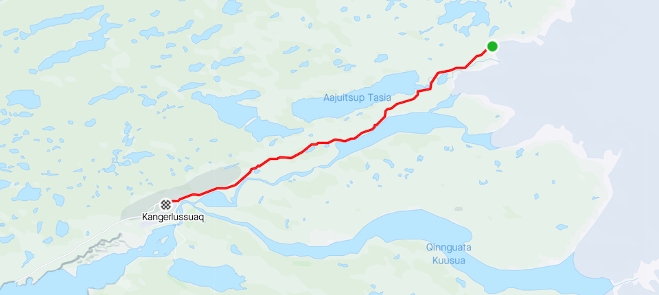
Arctic Circle Trail Day 2: Russell Glacier Israndsdalen to Kangerlussuaq Camping
Distance: 29.01km, Ascent: 364m, Moving Time: 6h18
Total Distance: 37.47km, Total Ascent: 498m, Total Time: 7h58
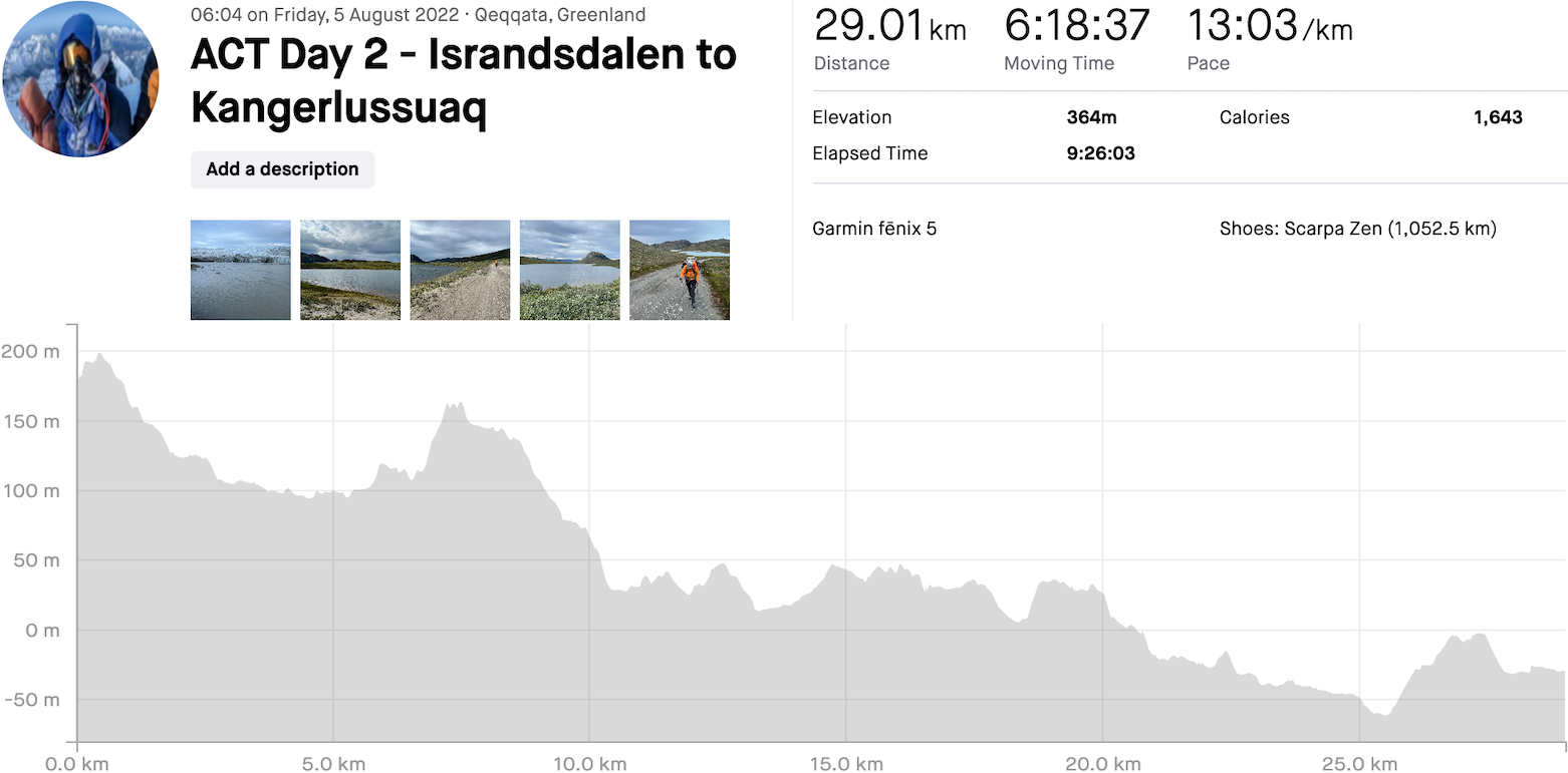
The night was a long one; the sound of wind, rain and a huge carving of ice ensuring that sleep came in spits and spats. Having no idea when the rain would eventually stop we decided to stir around 5h30, get everything packed, skip breakfast, and walk in the rain!
Whilst nothing more than drizzle it didn’t let up for a good 4 hours, the occasional slowdown allowing us to eat breakfast and a quick coffee. Soon after we came upon a group of musk ox including babies blocking the trail ahead of us, and whilst usually I’d have the big lens attached and be snapping photos the weather just didn’t motivate me! They soon ran off into the hills, our presence not pleasing them.
The dirt road also didn’t let up and after the first 10kms it became all about just getting back to Kangerlussuaq. The 30kms with heavy packs took its toll on us both – we were ravenous and devoured lunch of a wrap ‘loaded’ with a skinny sausage, some Danish cheese, sundried tomatoes and dollops of Branston pickle. Being back in Kangerlussuaq meant we could also hit the supermarket for crisps and bananas, followed by phone charging and free WiFi at the airport.
With the trip out to Point 660 being an extension to the typical ACT it bought us right back through town and increased the hiking distance to over 200kms. Another transport option is to take a taxi to Kelly Ville some 16kms along a paved road leading to the harbour that services Kangerlussuaq. Kelly Ville is classed as the official start of the ACT.
We ended the day at Kangerlussuaq Camping, right at the airport as most things are in this small town! For the second night running we fell asleep to rain falling onto the tent.


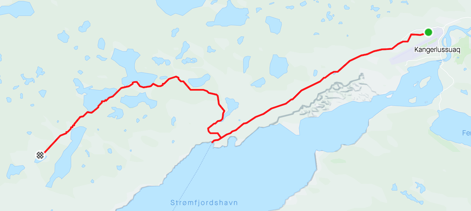
Arctic Circle Trail Day 3: Kangerlussuaq Camping to No-name Lake
Distance: 28.95km, Ascent: 699m, Moving Time: 7h15
Total Distance: 66.42km, Total Ascent: 1,197m, Total Time: 15h13
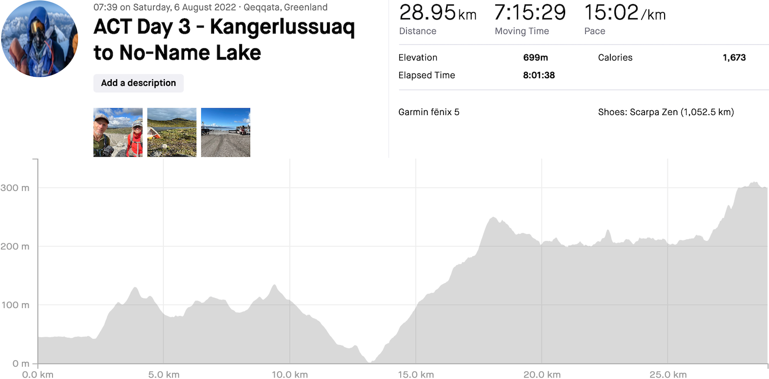
Waking to sun, glorious sun was just what we needed. It had rained on and off a lot of the night but the wind dropped and we slept like babies! This wasn’t quite on the forecast and being in Greenland meant things could change on a whim, but hey we’ll enjoy it whilst it lasts – we wasted no time on prepping breakfast and departing…
Although we were still sore from the previous day, as mentioned earlier we had almost 16kms of easy road walking to begin the day. This would leave only 4kms of trail to get to the hut at the official (Cicerone book) end of day 1. The kilometres flew by and the weather stayed perfect! After a couple of hours we were at the intersection for the harbour and Kelly Ville – whilst Andrea did some hip pain remediation I went and checked out the harbour and the newly arrived few hundred passenger cruise ship.
The ACT would begin proper in 3kms, and with it from what we’d heard would be a very boggy trail. At least we would be away from civilization, the coming days occasionally spent with fellow hikers on this ever popular trail to Sisimiut. We weren’t let down; there was water everywhere – navigating around it was often a pain in the ass with the unassuming bog plants easily swallowing a foot! Pretty much on queue the ramshackle caravan/ shed-addon for night 1 came into view. There was no way we were stopping so early, even though each day only required 23kms of hiking to finish in the planned 7 days.
An enjoyable lunch was taken on the sunny shores of Lake Hundeso before heading off out of this brackish lake area for a final 8kms to a lake without salt! We found the perfect spot a few feet from the waters edge, pitched the tent and got naked for a deserved washdown! The day was far beyond our expectations, almost the entire time spent in warm sunny Arctic weather. Sleep came easily even with barely any darkness, probably something to do with the days exertion.


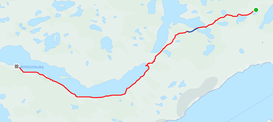
Arctic Circle Trail Day 4: No-name Lake to Big Cairn Plateau
Distance: 27.36km, Ascent: 491m, Moving Time: 7h29
Total Distance: 93.78km, Total Ascent: 1,688m, Total Time: 22h42
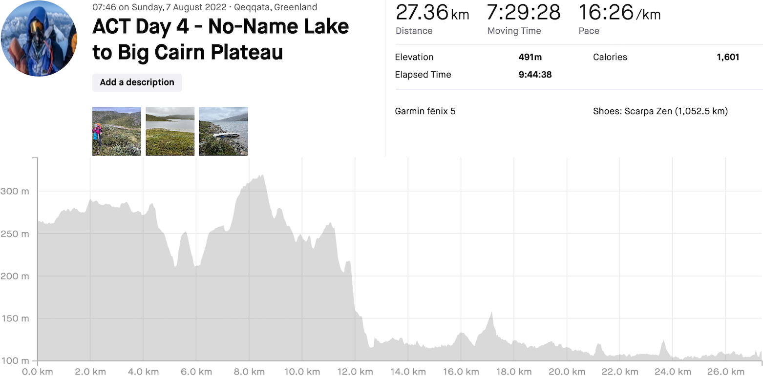
By 3am it was once again raining, a very typical pattern – would we ever wake to a dry tent? Our Garmin InReach weather forecast had already confirmed that unlike the day before it was going to be a wet one. We hoped that wherever the report originated had zero idea!
Our breakfast of roasted oatmeal and nuts combined with freeze dried mango, banana, blueberries and rehydrated kiwi was to die for, almost better than what we eat at home! This certainly set us up for the day ahead and is something that we’ve been preparing for many prior adventures. This morning was a rush departure as we demolished camp in between showers.
First off we had 12kms to make it to the official end of stage 2 at Katiffik hut. From there we planned on pretty much the same distance again and camping wherever we could find a bog free area! Bog was quickly becoming our nemesis and although we managed to avoid a lot of wet terrain at the beginning it was a lost cause – we soon had to ring the water from our socks and insoles! The hut was a welcome change, and not just another place to repeat the shoe water removal process. It was time for a second coffee and an extended snack break.
As we left the weather changed from showery to almost continual rain. We were at the head of Amitsorsuaq Lake, a 20km trail following it’s shore to the Canoe Centre hut, or if you were lucky a canoe or two would be waiting to make the trip, dropped off by some kind souls doing the reverse journey. We weren’t [un]lucky and missed out by a few minutes! Ten kilometres into the trail we found the same canoe abandoned on shore, discovering the following morning that battling the lake chop into the wind didn’t quite work out so well.
We’re glad we had no choice but to walk, even in the relentless bog and stop/ start rain. The local wildlife didn’t seem to care; a half dozen arctic hares eating and playing on a hillside, then a reindeer laying down that refused to be intimidated by us whilst we sat and ate lunch.
Our biggest problem was finding a place to pitch a tent that wasn’t on a sponge! Eventually higher ground offered a couple of options and although we were pretty close to just walking the entire way to the Canoe Centre hut I called the shot and put a halt to the pretty miserable afternoon. The tent was erected in crap conditions and we crashed out for a while.
Putting on wet socks and shoes the next morning wasn’t going to be fun; the best we could do was ring as much water out as possible and hope for a sunny day. I was far from optimistic with the Garmin forecast! Although breezy, enough water was boiled for a tasty ramen noodle dinner and we hit the sleeping bags until 7am.
 are the big feature on the ACT")

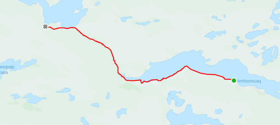
Arctic Circle Trail Day 5: Big Cairn Plateau to Kangerluatsiarsuaq Lake
Distance: 20.78km, Ascent: 251m, Moving Time: 5h28
Total Distance: 114.56km, Total Ascent: 1,939m, Total Time: 28h10
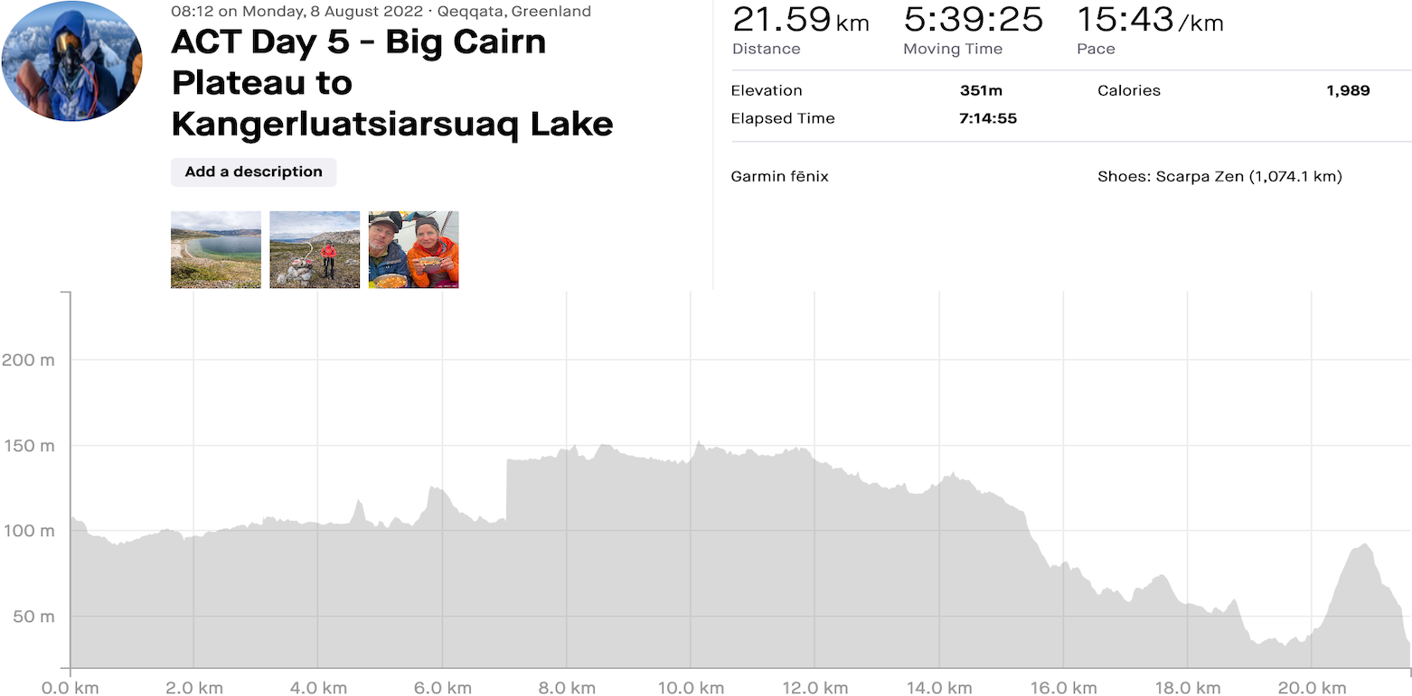
Not sure if it had anything to do with things but singing ‘the sun will come out tomorrow, bet your bottom dollar that tomorrow…’ seemed to bring on a much better looking day – there was nothing that was going to fix the sodden shoes now or the bogs but a bit of sun does wonders! We weren’t quite there yet but there was optimism. The night had been amazingly calm with no rain, the first of a few more maybe!
We were on the trail a little after 8am, first continuing along the glass-like lake until the hut and then hopefully making it another 22kms to the next hut – we would then be close to the halfway point.
As we neared the Canoe Centre hut the sun shone, the solar panels were attached to the backpack, and we were happy. We had already given up on avoiding the huge patches of spongy terrain; a repeat of yesterday already on the cards. This hut is the largest on the ACT, sleeping at least 20 people, with solar panels for charging, a heater and plenty of cooking space. We were still happy with our campsite selection and used this as a nice mid morning stopover.
The trail seemed to get drier, more rocky underfoot, until we reached the end of the lake another 4.5kms further. Then things changed – lots more, pretty much unavoidable bog! Every 5kms the plan was to stop, eat a snack (in my case, eat everything in the snack bag!), take a quick rest, and continue on. The weather stayed glorious, the mountain and lake views were epic, and a few reindeer avoided us like the plague.
It was taking not far off of 2 hours for each 5kms, the thought of banging out 22kms a bit daunting. Having read the upcoming trail report in the Cicerone book we knew there was a beach on the shore of Kangerluatsiarsuaq Lake, a beach that reportedly looked like it could be in the Mediterranean – on this reasonably sunny day we were sold. As long as it would take us over the 20kms mark for the day then we’d camp there.
Upon reaching the lake we were almost premature with camp choice, completely the wrong side of a small peninsula we quickly realised we had to go up and over. It was soon obvious, and heading down I could feel the legs pick up a gear to grab the perfect spot. There were other hikers behind us and I didn’t want to miss out! The tent went up in no time, our belongings layed out like clockwork – it was now time for the second lake wash. Bolluck naked was the way to go, and boy did it feel good!
Then the rain started… and it barely stopped until after sunrise. All we needed to do was boil water for mashed potatoes and veg and the rain wasn’t going to stop that. As usual dinner was tasty and set up bedtime to a tee, our only thought being the wet socks and shoes that were waiting early the next morning, again!


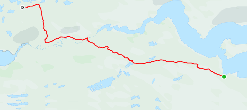
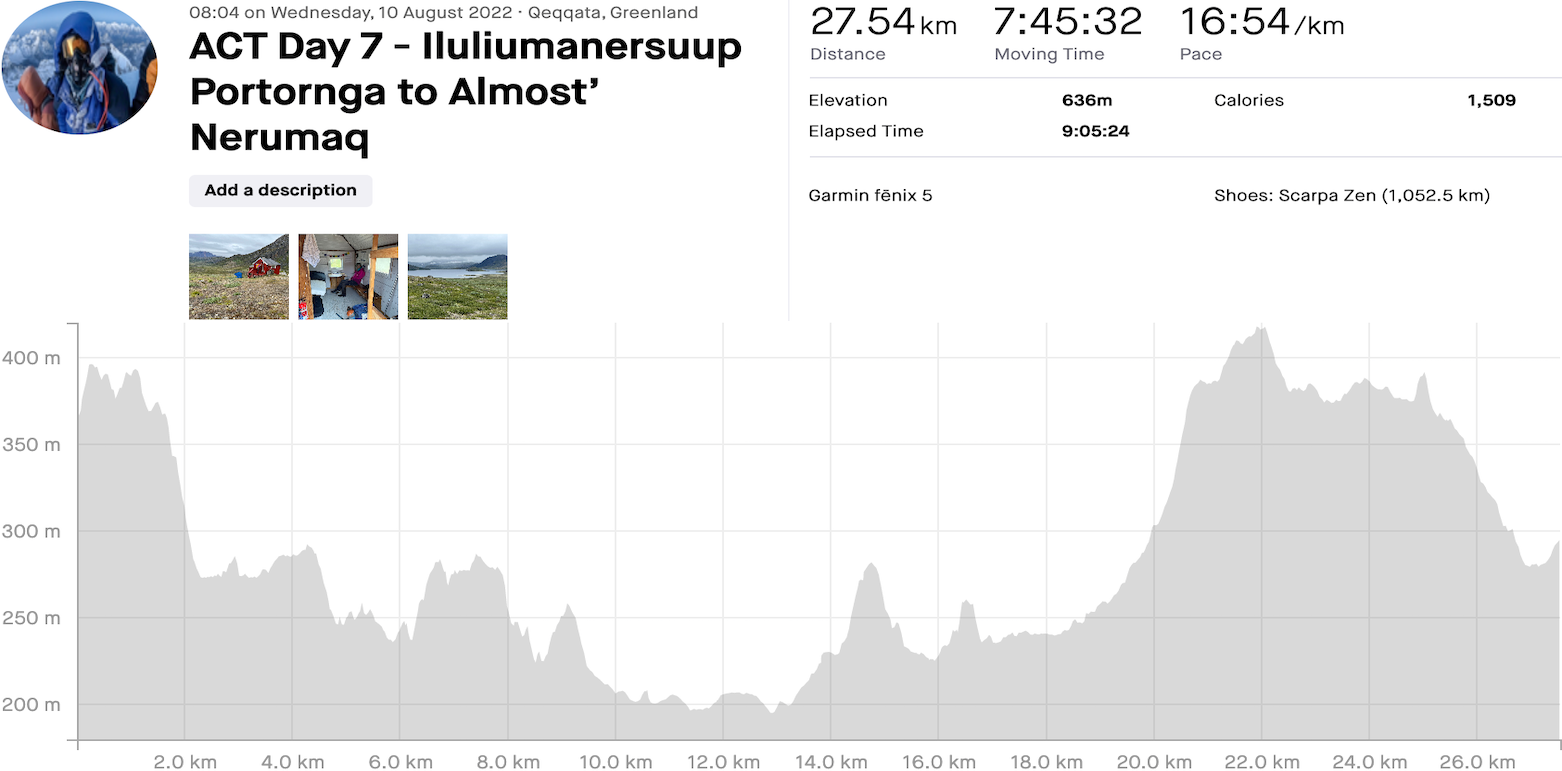
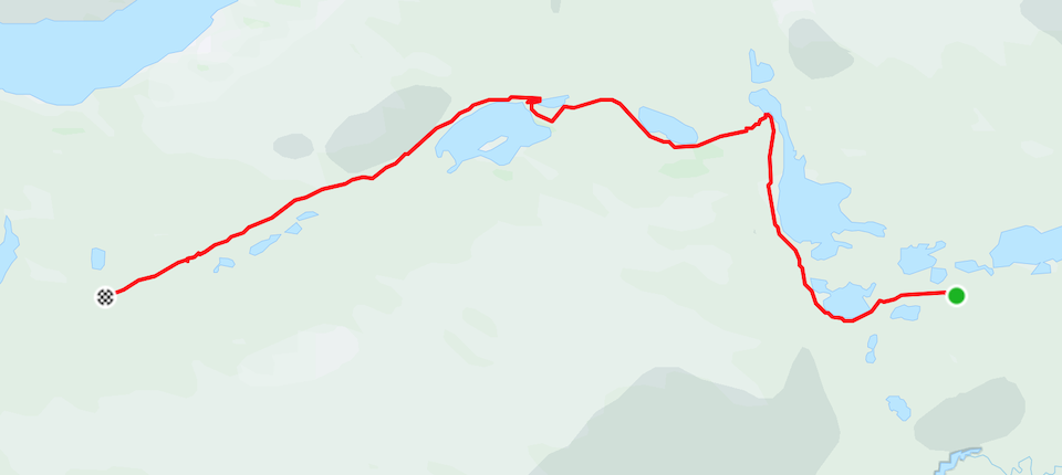
Arctic Circle Trail Day 6: Kangerluatsiarsuaq Lake to Iluliumanersuup Portornga
Distance: 27.69km, Ascent: 1163m, Moving Time: 7h40
Total Distance: 142.25km, Total Ascent: 3,102m, Total Time: 35h50
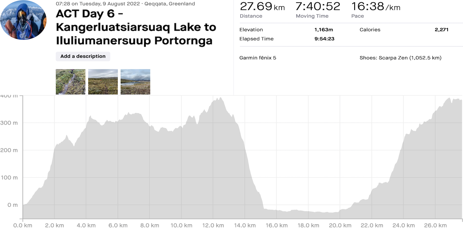
We were getting concerned we’d be walking in miserable weather, the rain not abating until around sunrise at 4:30am. Instead it was very overcast and breezy, no signs whatsoever of even a sniff of sun. Having had a somewhat strenuous but shorter day yesterday it was time to up the distance and make sure we would still be finishing on time.
Departing at 7:30am we ‘assumed’ it would take a couple of hours to cover the short 8kms to Ikkattoqq hut. Haha, not likely! There was almost 500m of ascent, and although easy there was so much wet terrain that seemed to take an eternity to manoeuvre around – we tried so hard to keep our shoes from getting fully submerged but it was always just a matter of time. Eventually we reached an altitude of 350m and began making our way down with only a narrow valley to navigate through to our goal. Initially it was a speck of red in the distance, soon becoming a mid-morning rest stop. It had taken almost 3 hours to cover 10kms!
Concerned that our gas bottle was running low we hoped a partial one would be lying around around in the tiny shed sized hut, to no avail. It would have to be snacks and no hot drink! Not hanging around long we moved onwards to bang out a short stage 5 of 11kms, the highlight being the widest and deepest river crossing of the ACT – we had a good report the previous day that the water was only waist deep, ugh!
After a bit of a climb the descent took us across the worst bog so far, ensuring we totally gave in to having waterlogged shoes. At least this made the river crossing easy! Stripped down to boxer shorts and a thong (for Andrea that is) we forded the river still wearing shoes and socks. No big deal, just made the final 5.5kms to the Eqalugaarniarfik hut miserable, plodding through lots more standing water and spongy terrain. It was a pleasure to arrive, the discovery of a gas bottle meaning we could splurge on hot drinks! The lunch wraps went down a treat.
If the weather had been more than just overcast we might have stayed but due to the relatively early 4pm time we hit the trail again. This was now stage 6 of 9 with approx 75kms remaining to Sisimiut. It was also at this point a decision needed to be made about taking the regular ACT along a northern route, which has some ATV tracks crossing the trail, or a supposedly newly marked and cairned southern route – we hadn’t met anyone that had done this so decided to stay north. For info: there is now an ATV track that connects Kangerlussuaq to Sisimiut, with discussions about a road project.
Stage 6 would ascend 680m over its 19km distance – we were hoping to bang out some of that incline before stopping for the day. The trail from the hut rose pretty steeply, sometimes on the ACT and sometimes on ATV track – we weren’t fussed either way as the views were still amazing in every direction! We stopped a further 5kms after the hut in another of the pretty cool camping spots we seem to come across – time to dry feet and cook. Sadly, removing our sodden shoes was the highlight of the day!


Arctic Circle Trail Day 7: Iluliumanersuup Portornga to ‘Almost’ Nerumaq
Distance: 27.54km, Ascent: 636m, Moving Time: 7h45
Total Distance: 169.79km, Total Ascent: 3,738m, Total Time: 43h35
Today was an exciting one as our Garmin had said 10% chance of rain and 70% cloud cover – we instead woke to another dreary day with no sign of sun and a big sign of rain! It was extremely calm out though and hadn’t rained overnight which was a rarity. This was also the fourth day of having to put on still soaking socks and shoes. Greenland, can we have some sun please?
We left to a pretty chilly morning, hopeful that all the bogs had dried up overnight! The initial kilometres were fine, then light rain started, then as we followed along a lake the bogs became more frequent, eventually turning into what felt like a floodplain. Time to give up caring! We had left with 14kms to the next hut and and it was painfully slow going, taking us 4h20 to cover the distance.
It was easy to see the amazing views but just didn’t quite make me want to stop and take the magical photos I was hoping for. Still, it was cool to admire the countless lakes, often reflecting the mountains, and see the occasional reindeer trotting off and blending in to the landscape. We still haven’t seen our Arctic fox!
The two huts at Innajuattoq were just as all the others; painted red, fairly well taken care of and boasting stunning locations. We took time out at the upper smaller hut, had lunch and once again, rung out socks and insoles! The plan was to go for another 9kms giving us 23kms for the day and splitting the final 3 days up perfectly. First we had to cross another river, and although shallower than yesterday’s it was difficult to find a way across where boulder hopping would work – Andrea tried but chose to just walk on through in the end. It really didn’t make any difference!
After the river the trail was finally mostly solid ground, the occasional marsh to manoeuvre around but all in all more enjoyable. The weather improved slightly, in that the rain had stopped, but low clouds had settled on the mountain tops totally obscuring any views. The kilometres ticked on by, Andrea continued at what sometimes seemed like snail pace, and we stopped too many times – I was impatient and wanted to hit the magical 23kms target and find another perfect place to camp.
Unfortunately we were hiking on the side of a valley with bog and waterways down below us, an ATV track running almost parallel, and too much of a slope all around us. We just kept on walking; 4pm became 5pm, 23kms became 25kms became 27kms, and then…
Rocky and drier terrain emerged, the options for pitching our tent becoming better. A few boggy lakes were scattered around and we found a nice flat spot on what could overnight become a bad idea. Our crappy REI branded tent was exposed to any wind and rain that might come our way, and this being Greenland our nice calm night might not be so nice and calm!
This being our penultimate night we felt it only right to tear open the one and only store bought camping meal each. Both were excellent – Andrea enjoying Mexican quinoa chilli and me devouring as usual a hefty portion of jambalaya! Tomorrow we just eat whatever remains. The night sky even gave us hope for the following day; instead of the bland grey we had seen all day it turned to different shades, maybe with a few hints of blue mixed in.
The way things were looking this was going to be another calm and chilly night.


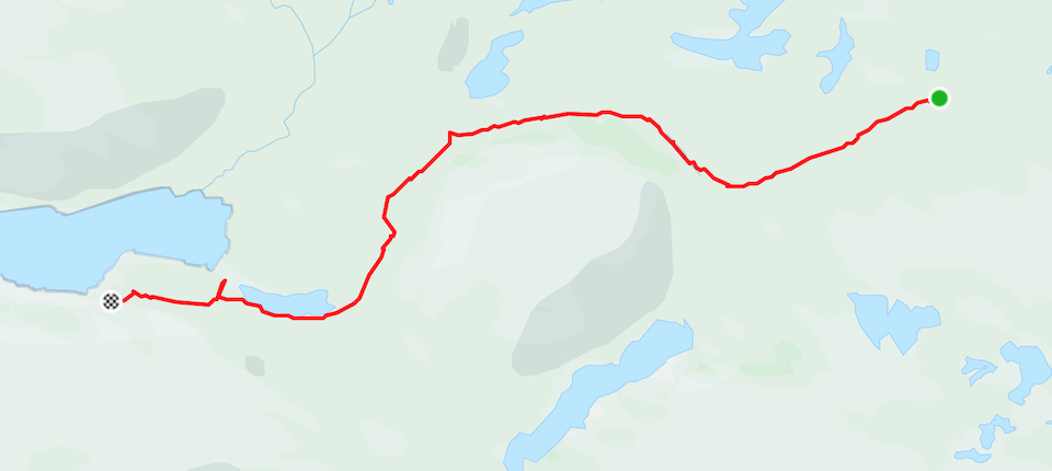
Arctic Circle Trail Day 8: ‘Almost’ Nerumaq to Kangerltuarsuk Tulleq Fjord
Distance: 27.03km, Ascent: 393m, Moving Time: 7h29
Total Distance: 196.82km, Total Ascent: 4,131m, Total Time: 51h04
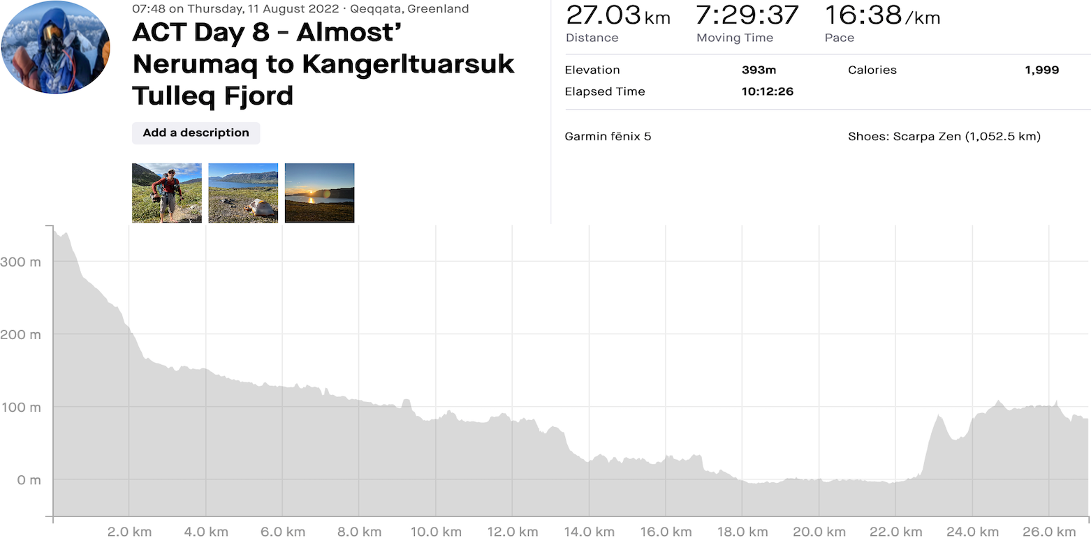
Waking to a 6:30am alarm call was rare, maybe the Greenlandic weather god telling us the day was already looking good and that we should get a move on! We actually had views of the higher surrounding peaks and got a glimpse of the day ahead.
We had completed most of stage 7 the day before so had only around 6kms to reach Nerumaq hut. The plan was to skip right on past and continue through stage 8, hopefully even making it beyond a couple more kilometres. This would give us a comfortable finale.
As usual the worst part of the day was putting on cold wet shoes and socks, along with disgusting trousers – our spare socks and trousers were keeping us toasty at night and would be needed once we arrived in Sisimiut. Our feet were always miserable for the initial kilometres! Having left camp we remained well above the swamp below avoiding anymore water; how long this would continue we had no idea.
Fortunately it did! There were a few sketchy areas but overall we hiked on harder ground all the way to Nerumaq hut. I barely poked my head into the ‘okay’ hut before we moved on, the first of 3 river crossings almost immediate. Sometimes it’s necessary to wade through the cold water but on this occasion we boulder hopped easily to the other side. One down, 2 to go! Continuing on, we passed countless braids of small water flows, fought our way through areas of head high shrubs, and navigated around the occasional bog. Still we avoided getting any wetter, at least for the time being.
The sun shone down, the sky was blue, and this was turning in to our best day in Greenland. Then we arrived at river crossing 2, really no big deal – a simple removal of shoes and socks, then walk right on through the cold and not particularly deep water in minimal flipflops. Andrea decided to just walk straight on through and ignore the squelching water in her shoes. The rocks were slick, I was one step away from shore, and down I went; camera, phone, shoes and socks, and most of what I was wearing, soaked! Andrea rescued one flipflop, the other making its way downstream – so much for carrying 100% of our garbage out with us.
….and I desperately needed to drop a no. 2
The toilet was priority number one, getting rung out shoes and socks back on, and hopefully the sun would do the rest. If it had been a day earlier I would have froze! The wind was chilly but slowly things became drier; the camera on the other hand was far from happy. Fortunately hopping back across that same river a little later was uneventful.
Unlike me the trail remained dry pretty much until the huts of Kangerltuarsuk Tulleq. We were 23kms into the day and wanted to try and dry things out at the hut, that is until I tried the door and realised it was a fancy fisherman’s cabin – ooops, I hadn’t realised we still had another 3kms to go almost!
A few more boggy patches ensued whilst we made our way to a hut that looked far too far away. The positive being that we had reached Kangerltuarsuk Tulleq Fjord and were now only a days walking from the sea. The hut provided us with a place to start drying our shoes and take a tea break whilst we weighed up whether to continue on. There was no chance of us wanting to stay in the hut but would there be any place to camp further along the sloping trail?
The gamble was taken and we marched on! In less than a kilometre some of the boggy grass had dried out somewhat – kneeling down in a flatter patch to make sure it really was dry the decision was made, this was home. The views of the fjord were epic and the sun still had a good few hours of heat output. Our shoes, insoles and socks were the first to be layed out on the spongy grass, wishful thinking that tomorrow we won’t have to put on anything wet!? We threw together a final dinner of everything left and lay outside amidst the mosquito infested grass. Life was good, the day had been ‘almost’ perfect, and our clothing was very close to being dry.


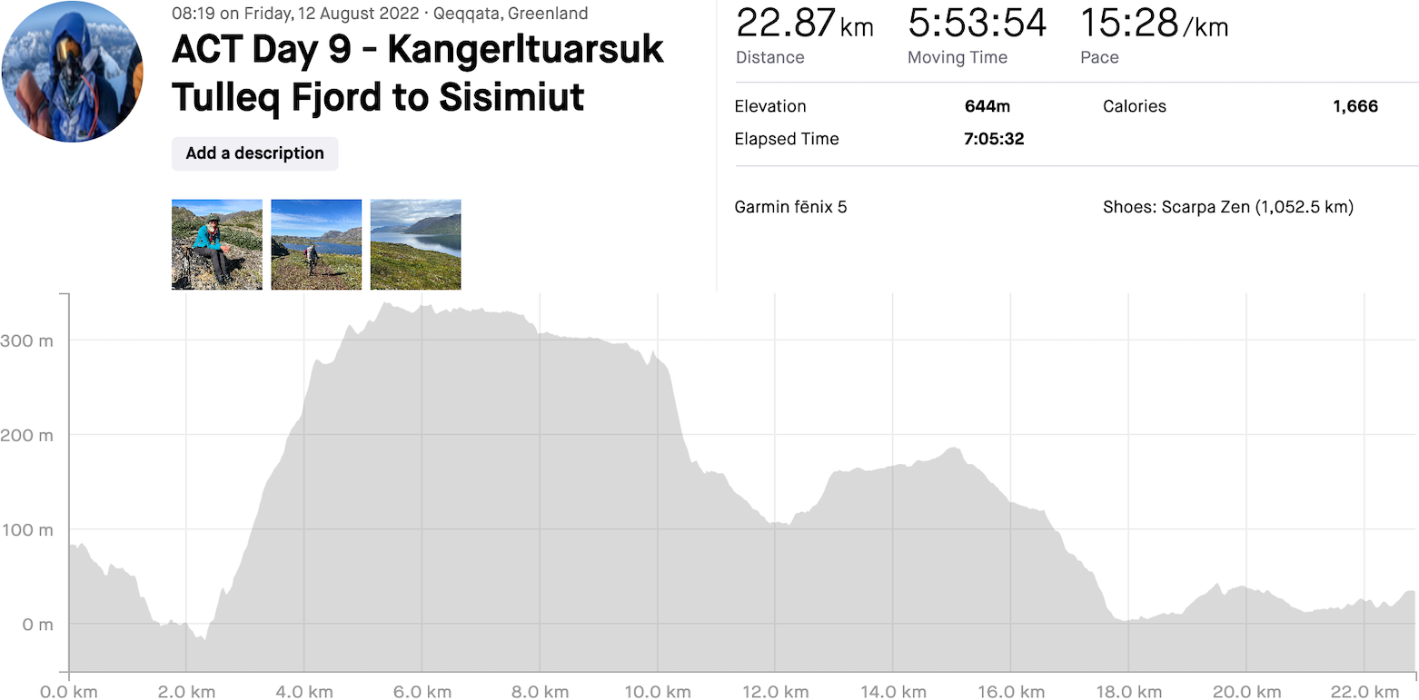
Arctic Circle Trail Day 9: Kangerltuarsuk Tulleq Fjord to Sisimiut
Distance: 22.87km, Ascent: 644m, Moving Time: 5h53
Total Distance: 219.69km, Total Ascent: 4,775m, Total Time: 56h57
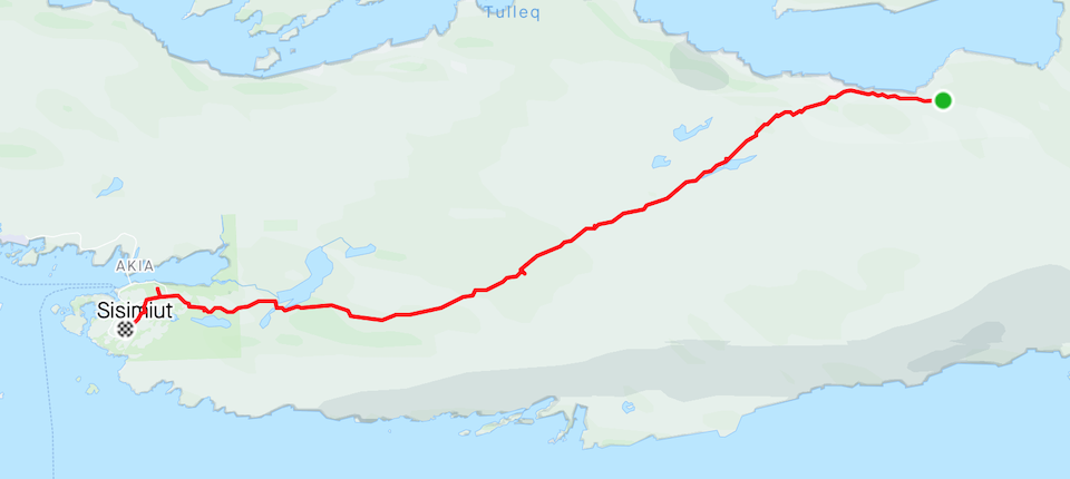
Totally against what our crap Garmin predicted the rain came down, beginning around 3am, still continuing at our 7am alarm time – this wasn’t meant to be. It was a little concerning that our dead looking bog would come back to life and be a swamp before we packed up! Once it calmed to a slight drizzle we ventured outside, the sky littered with blue patches. The day had threw us a fright but optimistically looked like it was going to be amazing.
Mosquitoes were just as the previous night and bugged the shit out of us. With our MSR stove playing up we had no excuse not to be packed up and on the trail faster than the tiny vampires could bother us. Following along the Kangerltuarsuk Tulleq Fjord the views were stunning; good reason for the many private cabins scattered along the far shore. Soon the trail ascended, a steep path taking us passed a funky looking toilet, and on to 400m above the fjord. Snow patches had emerged alongside the trail, remnants of the harsh Greenlandic winter – its ‘going’ to be amazing to come back and do the trail in winter!
The trail was almost perfect, the warmth of the sun drying the rain from the trailside plants and the bog becoming less and less of a bog. Only 2 fords showed on the map, the first river requiring a bit of boulder hopping and the second Andrea just waded on through – I chose an intricate route across using partially submerged rocks and careful balance! Looks like at least my dried out footwear was going to stay that way.
A final lunch stop for wraps, cheese, sausage, sundried tomatoes and branston pickle was taken in an idyllic location, mountains dominating our view. Another few kilometres and we should see some civilisation, both welcome and unwelcome at the same time! It was definitely sad to be leaving the remoteness of the ACT but exciting to see another part of Greenland.
…and then there it was, a distant view of the sea and buildings on the edge of Sisimiut. Our distance for the day indicated another 5kms; only an hour or so and we would be drinking a beer and eating whatever we could get our hands on in the first supermarket we could find! The time went by slow, our legs suddenly becoming a lot more fatigued. We passed by a couple more lakes, then an area on the outskirts of town with hundreds of noisy Greenlandic sled dogs, before finally moving from dirt to paved road.
Frustratingly a signpost stated that Sisimiut youth hostel was still a further 2.2kms away! The shower can wait – it was time to enjoy civilisation and grab whatever looks compelling at a surprisingly good supermarket. Not sure about the concoction of grapefruit, crisps, and currant buns washed down with chocolate milk, beer and Fanta though! Making it to our hostel accommodation we called it The End. The harbour could wait until the next morning!
The evenings celebratory dinner at Restaurant Nasaasaaq (Hotel Sisimiut) with our German hiking friend was the perfect way to call this trip an outstanding success. Just not too sure about the whale skin 🙂


Thoughts
Not that there’s anything wrong with winging it but when planning and execution go almost smoothly it makes for an enjoyable experience, along with making the next trip an exciting thought. Bring on the Kungsleden trail… We had dehydrated all of our own food, used the huts purely for brief hot drink stops and to chat with fellow hikers, avoided most of the crappy weather, enjoyed lots of wild blueberries, camped in some sublime spots, only fell into one river …and managed to avoid polar bears!
The low points were the persistent mosquitoes and midges, usually only kept away by wind and rain, and having soaking wet feet for five days due to the often relentless bogs – we were told that due to the later than usual winter, water hadn’t subsided like it typically does, leaving significantly more squelching underfoot.
Not sure how long this trail is going to be the remote experience it currently is, with the already established ATV track, mentions of a ‘proper’ road connecting the two towns, and the unexpected amount of trash (especially toilet paper you filthy pigs!) around the huts, but for the time being the ACT has to be a big bucket list item.
Notes
Mobile Data: Greenland tourist SIM card with the only provider, Tusass came in at an eye watering 800DKK per GB!! Not quite offset by the fact that the SIM card itself was free. We instead sat at the Kangerlussuaq airport and using their free WiFi purchased an eSim through Airalo at $9 USD per GB. Service was the same as buying locally!
Fuel: Propane/ Butane gas bottle x1 – 450gms 65DKK at Kangerlussuaq Pilersuisoq supermarket. We also used any bottles we found at the huts to make mid-morning and afternoon drinks.
Fishing kit: The plan was to buy the kit and a license, just didn’t end up bothering.
Gear List
Camping
Tent
Sleeping bags
Sleeping bag liners
Sleeping mats
Sitting mats
Inflatable pillows
Stove & lighters
Pots
Bowls
Mugs
Sporks
Knife
Insulated cooking pouches
Towels
Clothing Wayne
Flipflops
Rain jacket
Rain pants
Insulated jacket
Sun hat (didn’t use)
Baseball cap
Hiking pants x2
Long sleeved tops x2
Tee-shirt
Boxer shorts x3
Socks x2
Gloves warm (didn’t use)
Gloves thin
Buff
Food
Breakfasts x9 days (1 day extra)
Lunches x8 days…
Wraps, branston pickle, sundried tomatoes, cheese, sausage, jerky
Snack bags inc. dates, m&m’s, nuts, etc..
Mexican Mix
Dinners x8 days…
Day 1 – Mashed potatoes, lentil chilli, carrots/ peppers
Day 2 – Spaghetti peanut, broccoli, tofu
Day 3 – Mashed potatoes, lentil chilli, corn, broccoli
Day 4 – Raman noodles, carrots/ peppers, tofu
Day 5 – Mashed potatoes, lentil chilli, carrots/ peppers, corn
Day 6 – Raman noodles, zucchini, tofu
Day 7 – Jumbalaya/ Mexicain backpacking meals
Day 8 – Salmon, lentil chilli, carrots/ peppers, zucchini, corn, tofu
Personal
Plasters/ compeed
Toothbrush & toothpaste
Soap, shampoo, conditioner
Solar panel
Power bricks x2
Garmin InReach
Camera and lenses
Charging cables
Reading glasses
Sunglasses
Clothing Andrea
Flipflops
Rain jacket
Poncho
Insulated jacket
Midlayer jacket
Sun hat
Baseball cap
Beanie
Hiking pants
Tights x2
Long sleeved tops x2
Tee-shirt x3
Socks x3
Gloves
Buff
Sport bras x2
Underwear x8
Next Time!
Soto Windmaster stove – for windy conditions
Waterproof pants – Andrea
Crocs – water crossings
Insulated cooking pouches – burnt the ones we took
Sleeping mat – Andrea’s deflating
August 4th – August 12th 2022
Travel
Air Greenland Flights
Copenhagen to Kangerlussuaq, Ilulissat to Copenhagen (via Kangerlussuaq): 4,417 DKK Per Person
Albatross Point 660 Tour
Kangerlussuaq to Point 660: 650 DKK Per Person
Accommodation
Kangerlussuaq Camping: 60 DKK Per Person
Kangerlussuaq Hostel: 275 DKK Per Person
Sisimiut Hostel: 325 DKK Per Person
