
The cheapest but time consuming option would have been taking the 3 hour CTM or Supratours bus from Essaouira back to Marrakesh, heading across town to the grand taxi rank to wait for a shared 6 seater Mercedes bound for the town of Asni, finally followed by local shuttle bus. In all potentially taking 6 hours or so – with the help of Tripadvisor I found Aziz, the proud owner of Taxi Mogador, negotiated the 85 Euro rate and was picked up in a brand new minivan for the 4 hour ride. The long option wouldn’t have departed Essaouira until 12.45pm with CTM and worked out at approx 210 Dirham (20 Euro) for both of us plus the cost of a taxi in Marrakesh between the bus station and grand taxi rank!
Having no idea as to whether we would get a shot at Jbel Toubkal, and assuming that if we did then we would have to depart Friday, we only had accommodation for our first night. A pretty good walk up above the main town, Riad Atlas Prestige, had amazing views over the Atlas mountains, extremely friendly hosts, and as we were finding throughout Morroco, made excellent vegetable tajines. And it was dirt cheap – we were going to find that Imlil, and much of rural Morocco, was this way for everything!
This even applied to the cost for 2 people with a private guide to head up the highest mountain in North Africa. Booking through the official Bureau des Guides office in town we paid €100 for the 2 day trip, plus 560 Dirham for half board at Refuge Toubkal Les Mouflons and 280 Dirham for boots and crampon rentals. In total just under $100 each – certainly no complaints there! Alternatively most, if not all of the accommodation in Imlil will offer guides, official or not, to take you up the mountain. Incidentally guides are compulsory now since the terrorist murders of two Scandinavian girls in December 2018.


So we had a plan of attack; departing Imlil on foot at 9am Sunday, hopefully arriving back in time for Andrea to start work around 3pm on Monday. With weather conditions looking favorable it was exciting to be heading back into the mountains less than a year after bagging Everest – hopefully my still semi-raw amputated big toe wouldn’t be too pissed with t decision! Finding something to do on Saturday would be easy, as easy as just following any trail uphill.
Imlil was a typical small mountain town, complete with its fair share of used and abused gear rental shops, hole-in-the-wall outdoor retailers, souvenir stands and a boatload of auberges, dars, riads and hotels. We just had to walk down from our accommodation the once to have seen it all and been harassed by everyone – not that the locals were in any way problematic but one or two were verbally persistent. It was still early enough on the Saturday morning for us to get high, knowing where we actually wanted to get to but not sure how to get there.
We left town in an easterly direction towards the hamlet of Tamatert, almost an extension of Imlil but with less going on. The narrow lanes were lined with mud houses and occasional guest houses – goats and chickens foraging for brunch whilst Berber children played in the small schools playground. Soon enough we were looking down over the rooftops, our dirt trail continued on through groves of cedar trees along switchbacks before eventually popping us out on a dirt road at Tizi n’Tamatert, a mountain pass sitting at 2,279 metres.

At this dusty intersection it was a welcoming surprise to see a small refreshment shack with a couple of broken plastic chairs outside, the perfect place for a freshly squeezed orange juice or a mint tea. The mountain views and down into two valleys, Imane and Aït Mizane, were stunningly beautiful and desolate. We could see small communities and the occasional vehicle in the distance – curiosity wanted us to go delve deeper. Maybe on our next visit we’ll head out on a multiday hike or for a mountain biking adventure along these same long sweeping exposed mountain trails!
Today we wanted to go higher, a nice acclimatization day for Jbel Toubkal, in perfect North African conditions. The trail was obvious so we said our goodbyes to the old boy that served us and just continued on up, continually kicking up dust as we walked. Our Gaia iphone app didn’t show too much in distance but it also didn’t show us that the terrain would soon become rocky and require some creative route finding – we could see what we thought was the end but it soon became apparent that the ridge continued further getting ever higher. More scrambling ensued, sometimes just trial and error, as we basically just headed in the general direction of the now clearly seen summit. We passed by the only other people in front of us as they questioned continuing, changing their minds as soon as we showed our commitment to make the true highpoint.
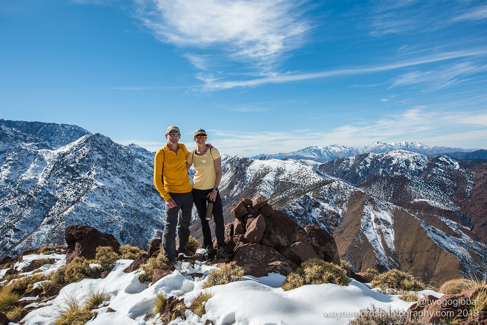
Not too long later there was nothing above us, at least not on this peak, and we got to take in 360° views of valleys, snow covered mountains and distant villages – it felt great.
Ascent of Jbel Toubkal


A single night on the mountain meant we weren’t bogged down with heavy packs, requiring only some warm clothes for an early summit day departure, a sleeping bag just in case the refuge blankets were all used up, some snacks, a couple litres of water and our well used rental crampons. We depart from our accommodation without even having to drop back down into town, the route following a dirt road through the Mizane Valley, first towards the village of Aremd (Aroumd) and then onto the shrine of Sidi Chamarouch. Aremd is the largest village in the valley and is home to a number of gites and traditional terraced farming, its Berber villagers having farmed this land for walnuts and potatoes for generations. The dirt road soon turned into a mule/ hiking trail as it passed through this harsh landscape.
This was the location of the first police checkpoint requiring that we register and ensure that there is a guide with us. New ruling requires hikers to check in to each of the three or four checkpoints en route to the mountain, however only when using the main trail – side trails and other areas in the Atlas were not under the same restriction when we were there in December 2019.
Continuing on passed an almost complete new police mountain facility, a few trailside snack joints, our next stop was home to the shrine of Sidi Chamarouch. The marabout shrine attracts both tourists and pilgrims but only muslims are permitted across the stone bridge leading to the actual giant painted white boulder – our guide mentioned that this is a very popular place to visit for a cure to your mental illnesses!


From here the trail snaked its way gradually up hill, the terrain under foot becoming more slippery as we made our way from dirt to icy patches to complete snow cover. As the trail straightened out the two refuges providing hiker accommodation came into view, still a fair way away but providing encouragement that we would soon be pigging down lunch and a pot of mint tea. We had made the 6.6 mile hike in under 4 hours ascending 4,309 feet. The refuge was impressive, almost like the relative luxury of the huts in the Alps – plenty of blankets to go around, comfortable chillout and dining areas, and to top it off, we had great weather!
Summit Day
On almost the same schedule as every other person holed up in one of the many dorm rooms we were up and at it by 2am, our departure set for 2.30. This was the day that I’d get to find out how bad the frostbite damage on my toe and fingers was – fingers I can do something about easily whereas the big toe could well suffer!
Eyeing the route up the previous afternoon, nothing that we could see had too much of an incline, our guide mentioning that the steepest section was actually in view. There was no reason to doubt that with Andrea wearing crampons for the first time ever we had anything to be concerned about – we also had no ice axes so could well do without terrain that might be a little technical! We plodded on up the lower slopes in the dark of the night, the few feet ahead of us illuminated by the beam from our headlights, the mountainside up ahead lit up by the lights of the few that had scrambled for an even earlier start. We only had around 2 miles to the top with 3,300 feet of elevation gain and with this mountain being significantly lower than a Colorado 14er this should be an easy stroll in the park; we already thought that we had left far too early!
The well kicked in path made life easy and other than the cold that was beginning to penetrate my borrowed boots this was a fun way to spend a very early Monday morning. Passing most of the early risers we made the top well before sunrise – it was brisk at the triangular summit marker and with my half-toe complaining about the lack of feeling it made for a nervous wait. Leaving a good hour or so later would have been perfect! Oh well, we did get to appreciate some pretty good sunrise colours on the descent.


The descent was straightforward, only this time we kept our crampons on well past the refuge, pretty much until the shrine – we had skated around a lot on the way up and decided a little more sure footedness would help. We made good time getting back to our Imlil accommodation, said our farewells to the excellent guide, and Andrea got to log in to work on time. A job well done!
The following morning it was back to traveling like the locals with no more expensive private transfers; a mule to carry our backpacks down into town, a rickety minibus to the larger town of Asni, and then an old shared Mercedes taxi back to Marrakesh.
We had had a blast and wouldn’t hesitate to visit Imlil and the Atlas Mountains again.
Transportation
Private shuttle from Essaouira to Imlil direct – 4 hours, Cost: 85 Euro
Minibus from Imlil to Asni – 30 minutes, Cost: 10 Dirham pp
Shared grand taxi from Asni to Marrakesh – 1 hour, Cost: 20 Dirham pp
Eating Out
Dinners for us were in our Riad accommodation. Always very cheap and tasty
Connectivity
Carrier: Maroc Telecom, SIM card & Data: 10Gb, Cost: 140 Dirham ($14.50)
Carrier: Maroc Telecom, SIM card & Data: 5Gb, Cost: 80 Dirham ($8.30)
Dates
December 20th – December 24th 2019
IMAGES
I think that with trial and error both my photography and website design are getting progressively better so hopefully these newer, better quality images will inspire you to get out there and travel. Click HERE to see more and if you like the content then feel free to comment.
