
Did summiting Denali back in 2003 subconsciously set this somewhat crazy adventure into gear? I’ll never know but what I was hoping for is that this would be the end, the finale, the completion, the conclusion, whatever… of bagging the highest point in all 50 of the US states. Unfortunately due to a typically nervous wife this didn’t turn out entirely as hoped. I should have known better!
These were all big boys, at least for the United States – with the Wyoming and Washington summits often spoken about in the same sentence as the toughest. Maybe its not the best idea to leave the potentially most difficult to last!
Oregon – Mt Hood
Elevation: 11,239′ / 3426m ● Summited: 6/7/25 at 6h59 ● Route: Up/ Down: South Side – Hogsback/ Old Chute – Mt Hood National Forest
Probably the easiest of the 3 remaining summits and the one that gave me the most concern. Early July is not an ideal time nowadays to be marching up a big pile of rocks with potentially little snow holding all the rocks together and above zero temperatures! The closer our scheduled July 6th summit day came the more concerned I became, especially when the Mount Hood climbing rangers put out their final update on July 3rd stating that they are not recommending anyone going for the summit this season – far too much potential for rock fall 🙁 Now if I could keep that update from Andreas eyes we might still have a chance!
The Sunday morning 12:30am alarm call came, we quickly ate breakfast and left our Airbnb for the 50 minute drive to Timberline Lodge and ski resort at 1740m (the resort is the only one in the US to be skiable for 10 months of the year). The parking lot seemed busy but there was no one around and we could see no lights heading up the mountain – maybe we are the only idiots!
The trail was pretty obvious and went from dirt to piste where we stopped to put on crampons – the pisteurs were out and it kind of felt like we were trespassing on the newly groomed ski runs. It wasn’t long before we passed the Silcox hut at 2133m followed almost 500 vertical metres later by the upper lift station at 2603m. From here on up we’d be following a hopefully obvious boot pack. We continued easily up the Palmer snowfield, sometimes following a skin track and sometimes following foot prints, all the time heading up towards Crater Rock. We climbed above Triangular Moraine and followed comfortable ground to the east side of Crater Rock, passing above the sulphur spewing Devil’s Kitchen at 3170m.

Andrea’s smile hides a bag of nerves in anticipation of the descent from the top of Oregon
We had made it up to the Hogsback, the climbing routes name. We roped up and continued ascending – this wasn’t the best place for a picnic with the pretty smelly odours seeping up out of the dormant volcano! From here we could see the summit ridge, the much-talked-about bergschrund and the Pearly Gates. It was pretty obvious we were going to be taking the late season option of the Old Chute which had more snow and passed well to the left of the very open bergschrund. We still hadn’t seen a soul so there was no fear in anyone sending missiles down on top of us, the biggest concern this late in the season.
A somewhat steep and obvious boot pack lead us up the Old Chute and pretty quickly topped out on a mostly snowless ridge – Andrea wasn’t going to like descending this! Traversing the ridge was longer than expected, following a meandering rocky path to a final section of snow and the top of Oregon. Now all we had to do was get back down.
After chomping down some energy bars and water we reversed the ridge, only this time we somehow dropped a bit far down the north side of the mountain (damn tracks). Although a short detour it made for a very steep bootpack to regain the ridge, a detour that terrified Andrea! She was brave and we were soon finished with the ridge, downclimbed the Old Chute and on easy terrain back towards civilization and the pistes.
Overall it was a perfect day with only 2 other people we saw later high on the mountain. The refreeze was perfect, no fear of rockfall, no crevasses, and a bluebird sky. It was a little weird to see all the skiers once we got to below Crater Rock though.
Mt Hood does sound like a great mountain to ski in the spring, so maybe one day…


Descending to Crater Rock
Washington – Mount Rainier
Elevation: 14,411′ / 4392m ● Summited: Bailed ● Route: Up/ Down: Disappointment Cleaver-Ingraham Glacier Direct (DC) route – Mt Rainier National Park
Moving on, we drove north via the Pacific coast, and after an overnight in Olympia checked into our airbnb in Elbe. This part of the US seems excessively outrageous for accommodation, especially anything along the road towards Mount Rainier National Park! At least we were now within an hour of Paradise where we needed to collect the necessary park and climbing permits – luckily our National Park “America the Beautiful” annual pass was still valid from the previous year.
Now, talking about permits, what a pain in the ass. A few months prior to our US trip I’d done a bit of research and found out that we were far too late to get the pick of the crop on the parks upper ‘climbing’ camping areas, and also that we each had to pay a $70 annual climbing fee – something that seems to increase substantially every year, and with it expiring on Dec 31 doesn’t even give you 12 months of usage. Then assuming we eventually get a campsite cancellation or a walk-up slot on recreation.gov we have to collect a team climbing permit in person, and show that all members have paid the annual climbing fee. Aside from the permits, there is a questionnaire to complete indicating the equipment you are expected to have, or may not have, with you!
Ooops. would the park rangers approve the climbing permit without us checking the box about carrying snow pickets? Luckily not, but they did loan us one; not one each but one in total. The ranger also mentioned that we should carry a gas cylinder, stove and sleeping bags on the summit bid, stating that any rescue could be up to a couple of days away – anyone would have thought we were in the jungles of Papua, not a few miles from Tacoma and civilisation! And without any further ado we were free to start our hike to Camp Muir.

Camp Muir half way up Rainier at 3105m/ 10188 ft
The weather was socked in at 1645m Paradise but the rangers had radioed up to Muir and gave us good news of clear blue skies. With heavy packs we plodded up the steep paved walkway, slowly making our way from the tourist masses and into a familiar looking mountain environment. Pavement soon gave way to dirt trails, occasionally still snow covered, eventually leading us up to Panorama Point at 2074m – our view was still about as good as pea soup so after a refreshment break we continued on up.
Beyond Pebble Creek we reached continuous snow, the beginning of what would take us up the Muir snowfield, and on to the mountains most popular campsite at 3105m. The terrain never really changed again, just a fairly long slog with the occasional steeper section – a lack of ice not requiring the use of crampons, and this time of year any crevasses still had a good covering of snow. There were plenty of places for rest stops on bare rocky sections scattered throughout the snowfield.
We continued to make good time and waltzed into camp well under 5 hours after leaving Paradise (something good to be said for living and working out at altitude). It was already fairly busy so we wasted no time in finding a somewhat flat section to pitch our new Hilleberg bombproof tent – that’s if you erect it securely enough! We were comfortable, the sky was blue, there were volcanoes on the horizon, and we could see the route for later that night.
…and then just like that the trip became somewhat worthless!


In the late afternoon, as we had heard, out pops one of the rangers from the continually manned stone station building. After giving his briefing to the closest group of tent participants he came over to the 15 or so of us that were milling around and started on his spiel. It was mostly related to the weather forecast, route conditions, etc.. but then went into gear, in particular who was carrying pickets – for some reason his gaze was aimed at us, upon which we said that we had one picket between us. Ooops!
How the heck was the person that didn’t have the picket going to secure and rescue the one with the picket that had just fallen in a crevasse? “Use my ice axe”. Have you ever tried to rescue someone using your ice axe as a snow picket? “No, but we have done crevasse rescue techniques in the Alps”. Blah, blah, blah… This was becoming like a personal lecture, luckily for us ending when our tent and all the contents was about to become airborne. Andrea took all of his words in, then realised that I was probably going to fall in a crevasse with the picket and she would have no way of securing me, upon which we would both probably freeze to death and die. We had also polished off our small bottle of gas melting snow so couldn’t take any gas with us to the summit – I mean, talk about fear mongering!
Thirty minutes later after digesting everything Andrea turned over in the tent and said that she was an absolute nervous wreck. That was it, I couldn’t argue, so just turned off the midnight alarm call. We left camp at 5am heading away from the summit route!
Wyoming – Gannett Peak
Elevation: 13,804′ / 4207m ● Summited: 15/7/25 at 6h17 ● Route: Up/ Down: Dubois East Access Glacier Trail – Wind River Range
Many blogs and online articles state that Gannett Peak is in the top 3 or 4 for difficult state high points to summit. I know where I would put it now that it’s over and done with. We had reconnected with some American friends for this trip, almost knowing beforehand that we would be doing the majority of this trip as a couple, the sheer distance from the trailhead to summit being the main issue. I knew we could do the distance, it was whether Andrea could handle the exposure on summit day!
We had tossed around the different route options, one being 10 miles longer than the other but requiring a significant approach descent on summit day, and with that a greater ascent on an already long final day. One of our initial team was all for the longer distance, coming in at around 50 miles roundtrip with 3300m of elevation gain, so we opted for that after some back and forth – the trailhead was close to the small town of Dubois, and to the north of Gannett peak. Apparently both of the main routes offered stunning scenery, with lakes, river crossings, mountains, and grizzlies in abundance.
As per the US State Highpoint Guide…
- Trailhead: Start at Trail Lake Ranch
- Arrow Pass (3320m): Ascend through switchbacks, reaching a high point with expansive views
- Burro Flat and Phillips Lake: The trail descends into open plateaus, passing picturesque lakes
- Double Lake and Star Lake: Ideal camping spots for the first night, with scenic views and access to water
- Dinwoody Glacier Base: Establish high camp at around 3100m to 3300m
- Gooseneck Glacier: Navigate crevasses and ascend to the summit ridge
- Summit: The final push to the peak involves crossing a bergschrund and ascending steep snow slopes
…and then turn around and repeat in reverse!
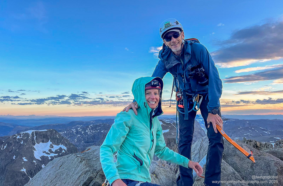
Happy to be at the Gannett Peak summit at sunrise
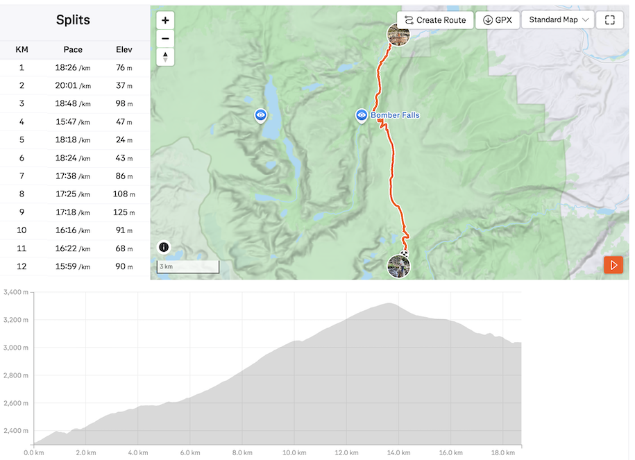
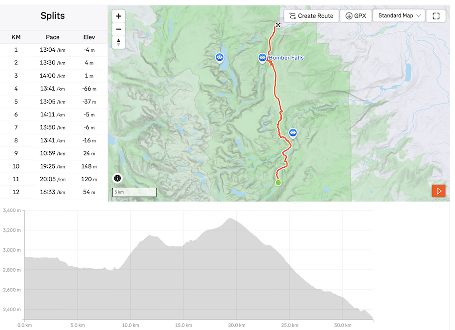
Gannett Peak Day 1: Trail Lake Trailhead to Double Lake
Distance: 18.71km/ 11.63 miles, Ascent: 1066m, Moving Time: 5h12
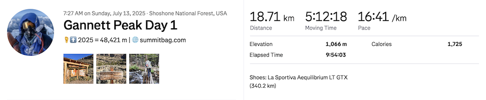
After leaving the main road leading to Dubois we took a 9 mile dirt road to the trailhead. Arriving late this would be home for the night, also allowing for an early start and a full day of hiking. The loosely defined goal was to make it as far as Double Lake,


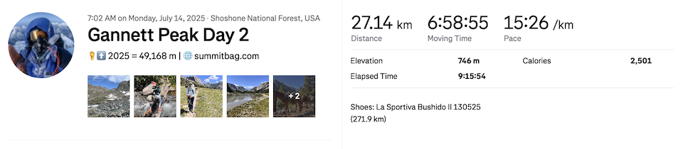
Gannett Peak Day 2: Double Lake to 3300m Camp
Distance: 27.14km/ 16.86 miles, Ascent: 746m, Moving Time: 6h59
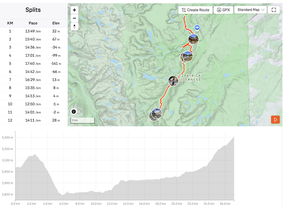


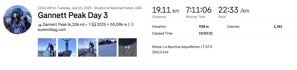
Gannett Peak Day 3: 3300m Camp to Ink Wells Trailhead Intersection
Distance: 19.11km/ 11.87 miles, Ascent: 928m, Moving Time: 7h11
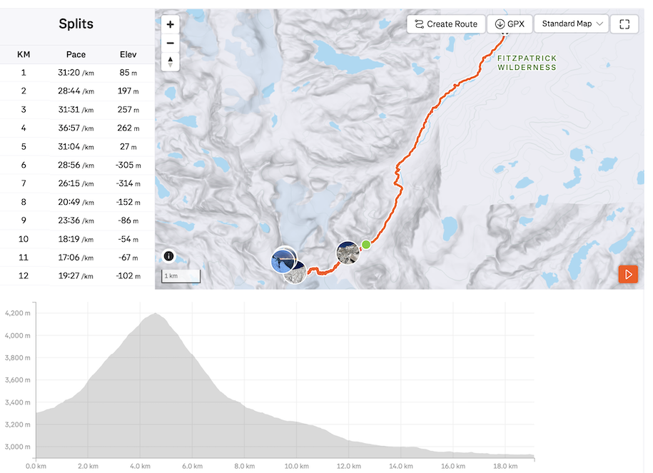


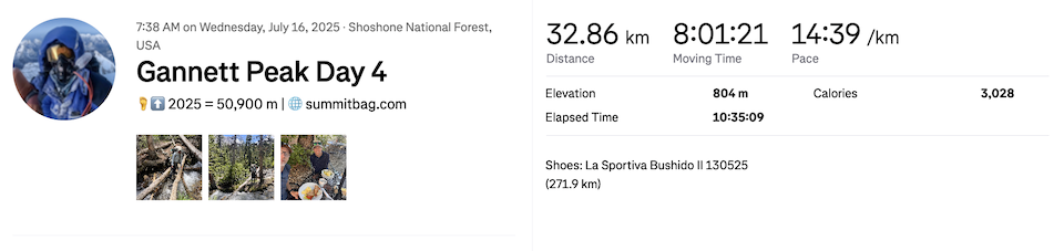
Gannett Peak Day 4: Ink Wells Trailhead Intersection to Trail Lake Trailhead
Distance: 32.86km/ 20.42 miles, Ascent: 804m, Moving Time: 8h01
I vowed that this would be my last trip to the US, ever. Now its either leaving one state highpoint behind or… not 🙁
Camping
Tent (Hilleberg)
Sleeping bags
Sleeping mats
Sleeping bag liners
Pillows
Towels
Head torches
Coffee maker/ filters
Stove/ gas bottle (bought in US)
Pans
Bowls
Mugs
Spoons
Knife
Bear storage bag
Sitting mats
Clothing
Running shoes
Goretex jackets
Down jackets
Baseball cap
Long sleeved top
Tee-shirts
Boxer shorts
Socks
Food
Breakfasts x11 days (Home made in US)
Snacks: trail mix, energy bars (Trader Joes)
Dinners x7 total (bought at REI)
Personal
Trekking poles
Garmin inReach
Water purifier
Nalgene bottles
Suncream
Toothbrush & toothpaste
Soap
Power brick
Solar Panel
Camera and lenses
Charging cables
Reading glasses
Sunglasses
Climbing
Crampons
Ice Axe
Harnesses (slings, rappel device…)
Rope
Helmets
Next Time!
A long drive north from Las Vegas and campsites in Yellowstone NP
Dates
July 4th – July 18th 2025
IMAGES
I think that with trial and error both my photography and website design are getting progressively better so hopefully these newer, better quality images will inspire you to get out there and travel. Click HERE to see more and if you like the content then feel free to comment.
